Cholesbury Camp ? Information Board
Introduction
The photograph on this page of Cholesbury Camp ? Information Board by Chris Reynolds as part of the Geograph project.
The Geograph project started in 2005 with the aim of publishing, organising and preserving representative images for every square kilometre of Great Britain, Ireland and the Isle of Man.

There are currently over 7.5m images from over 14,400 individuals and you can help contribute to the project by visiting https://www.geograph.org.uk
Cholesbury Camp ? Information Board
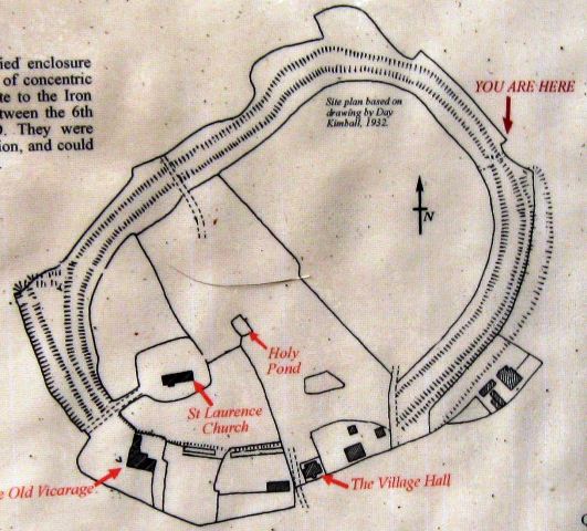
Image: © Chris Reynolds Taken: 11 Mar 2009
At this entrance to the Camp there is a large notice board with this map on it and a description, summarised below. Cholesbury Camp is a large multivalate hill fort on the borders of Buckinghamshire and Hertfordshire. This kind of hillfort was constructed during the Iron Age (between 6th century BC and the time of the Roman invasion). They were mainly used as centre of permanent occupation and could be defended in response to increasing warfare. Here the earthen ramparts lie within the wooded belt which encircles all but the southern quarter, where the banks and ditches have been obscured by houses and gardens. Two banks (internal and external) enclose a large ditch, which is the only defensive boundary to the north-east and north-west, but there are further banks and ditches to the west and south-east. The site is approximately oval, covering 10 acres and measuring approximately 310 m north-east to south west by 230 m north-west to south-east, with a level interior. Excavations in 1932 in the interior of the hillfort uncovered well-preserved remains of prehistoric occupation including seven heaths or fire-sites, and the remains of a clay-lined oven. Three of the hearths showed evidence of iron smelting. Pottery has been dated as from 300 BC to 50 AD.
Images are licensed for reuse under creativecommons.org/licenses/by-sa/2.0
Image Location
Latitude
51.757012
Longitude
-0.651835