IMAGES TAKEN NEAR TO
TRING, HP23 6JZ
Introduction
This page details the photographs taken nearby to HP23 6JZ by members of the Geograph project.
The Geograph project started in 2005 with the aim of publishing, organising and preserving representative images for every square kilometre of Great Britain, Ireland and the Isle of Man.

There are currently over 7.5m images from over14,400 individuals and you can help contribute to the project by visiting https://www.geograph.org.uk
Image Map
Images are licensed for reuse under creativecommons.org/licenses/by-sa/2.0
Notes
- Clicking on the map will re-center to the selected point.
- The higher the marker number, the further away the image location is from the centre of the postcode.
Image Listing (6 Images Found)
Images are licensed for reuse under creativecommons.org/licenses/by-sa/2.0
Image
Details
Distance
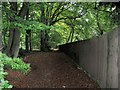
1
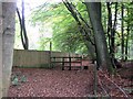
The Long Fence beside the footpath through Buckland Hoo wood
As the walk on the footpath through Buckland Hoo Wood (reference B17) gets less steep one comes to a “no bikes please” barrier and what appears to be a long garden fence along a line of mature beech trees,
Image: © Chris Reynolds
Taken: 17 Oct 2009
0.15 miles
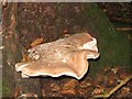
3
The Wood behind the Fence at Buckland Hoo
Peeping over the fence one can see that the other side is woodland, with no sign of “garden” management, but somewhat more open than the Buckland Hoo Wood. Where the fence starts near Long Meadow Farm it is gated, with warning signs, and another fence separates it from Long Meadow Farm, corresponding to a track on the maps. This area may be associated with Astonhill Place.
Image: © Chris Reynolds
Taken: 17 Oct 2009
0.15 miles
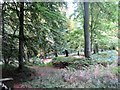
4
Two Trails through the woods at Buckland Hoo
At first sight one might wonder why there are two parallel paths through the wood – with only a strand of wire to separate them. However the path to the left is a public footpath in the Parish of Buckland (reference B17) while the track to the right is a mountain bike trail.
See Image
Image: © Chris Reynolds
Taken: 17 Oct 2009
0.16 miles
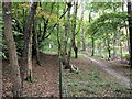
5
The Long Fence beside the footpath through Buckland Hoo wood
A view looking east, at the fence through the wood, along the line of old beech trees. At this point the footpath is designated A 13, so presumably this spot is in the parish of Aston Clinton.
Image: © Chris Reynolds
Taken: 17 Oct 2009
0.19 miles
6
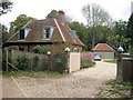
Long Meadow Farm
This may once have been a farm, but is now clearly a private house.
Image: © Chris Reynolds
Taken: 17 Oct 2009
0.19 miles