IMAGES TAKEN NEAR TO
Chesham Road, TRING, HP23 6HH
Introduction
This page details the photographs taken nearby to Chesham Road, HP23 6HH by members of the Geograph project.
The Geograph project started in 2005 with the aim of publishing, organising and preserving representative images for every square kilometre of Great Britain, Ireland and the Isle of Man.

There are currently over 7.5m images from over14,400 individuals and you can help contribute to the project by visiting https://www.geograph.org.uk
Image Map (Loading...)


Getting Data...Please wait
Leaflet Map data © OpenStreetMap
Images are licensed for reuse under creativecommons.org/licenses/by-sa/2.0
Notes
- Clicking on the map will re-center to the selected point.
- The higher the marker number, the further away the image location is from the centre of the postcode.
Image Listing (10 Images Found)
Images are licensed for reuse under creativecommons.org/licenses/by-sa/2.0
Image
Details
Distance
1
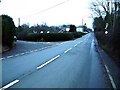
Wigginton Bottom
Not the most inspiring of Geographs, but it was a rather gloomy old day !
This photo Image shows the same area in rather jollier weather !
Image: © Rob Farrow
Taken: 15 Jan 2006
0.06 miles
2
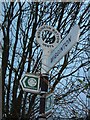
Wigginton Bottom Signpost
A supplementary image showing the "polo-mint" topped sign at Wigginton Bottom.
Image: © Rob Farrow
Taken: 15 Jan 2006
0.12 miles
3
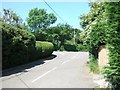
Wigginton Bottom in Summer
A rather cheerier looking Wiggington Bottom than that seen in Image
The signpost is the one seen in Image
Image: © Rob Farrow
Taken: 16 Jun 2006
0.12 miles
4
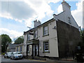
The Greyhound Public House, Wigginton
This was one of the public houses built by John Brown, of Tring Brewery, in the mid 19th century.
Image: © Chris Reynolds
Taken: 16 May 2016
0.15 miles
5
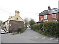
Wick Lane at the junction of Chesham Road
Image: © David Howard
Taken: 24 Apr 2014
0.17 miles
6
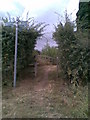
The Ridgeway
Footpath off The Ridgeway on the edge of Wigginton.
Image: © Burgess Von Thunen
Taken: 27 Jul 2010
0.17 miles
7
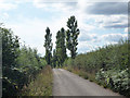
Poplar trees by road
These poplar trees on rising ground by the side of a private road can be seen from a considerable way away.
Image: © Tom Presland
Taken: 11 Aug 2010
0.23 miles
8
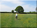
Chiltern Way at Wigginton
A long distance path. Here it goes across a pasture field with buttercups.
Image: © David Hawgood
Taken: 1 May 2011
0.24 miles
9
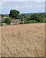
View from rear of Highfield Lodge, Wigginton
Looking across a field with plenty of wild flowers past the tops of a few houses on Osborne Way. In the distance the white tower than can just be seen is the top of Image] about 3½ miles (5½km) away.
Image: © Rob Farrow
Taken: 9 Jul 2023
0.24 miles
10
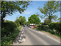
Chicane at entry to Wigginton
This chicane is intended to slow down traffic as it enters Wigginton. It is also an access point to the Chiltern Way.
Image: © David Hawgood
Taken: 1 May 2011
0.25 miles