IMAGES TAKEN NEAR TO
Wellbrook Mews, Brook Street, TRING, HP23 5SH
Introduction
This page details the photographs taken nearby to Wellbrook Mews, Brook Street, HP23 5SH by members of the Geograph project.
The Geograph project started in 2005 with the aim of publishing, organising and preserving representative images for every square kilometre of Great Britain, Ireland and the Isle of Man.

There are currently over 7.5m images from over14,400 individuals and you can help contribute to the project by visiting https://www.geograph.org.uk
Image Map
Images are licensed for reuse under creativecommons.org/licenses/by-sa/2.0
Notes
- Clicking on the map will re-center to the selected point.
- The higher the marker number, the further away the image location is from the centre of the postcode.
Image Listing (673 Images Found)
Images are licensed for reuse under creativecommons.org/licenses/by-sa/2.0
Image
Details
Distance
1
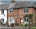
Cottages at Tring
These are in Brook Street, adjacent to the Market Place.
Image: © Gerald Massey
Taken: 9 Jul 2009
0.01 miles
2
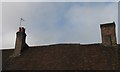
Tiled Rooftop at Tring
This very uneven tiled roof belongs to the shop adjacent to the Robin Hood public house in Brook Street.
Image: © Gerald Massey
Taken: 12 Sep 2009
0.01 miles
3
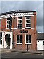
High Street, Tring
This building in the Lower High Street was built in 1880 by the Co-operative Society, and there was a Co-op store on the site until the 1980s. At some point the upstairs, which housed "Unity Hall", became Tring's first cinema, "The Gem Picture Hall", showing pictures that were "very fine and free from vulgarity."
Image: © Gerald Massey
Taken: 7 Jul 2009
0.02 miles
4
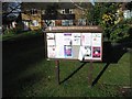
Town Notice Board, Mortimer Rise, Tring
Image: © Gerald Massey
Taken: 20 Nov 2009
0.02 miles
5
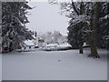
The Robin Hood from the Memorial Gardens, Tring
The Robin Hood pub is here viewed across the (almost) pristine snow of the Memorial Gardens, which occupy the land of the former village of Dunsmore.
The village was entirely demolished and turned into gardens by the Rothschilds as part of their estate. Later this part became the Memorial Gardens in memory of the fallen of the First World War, and subsequently the Second.
Image: © Rob Farrow
Taken: 8 Feb 2007
0.02 miles
6
Pavement past the Robin Hood
The Robin Hood pub is on the corner of the High Street and Brook Street in Tring. It is at a lower level than the road that passes it so the pavement is in something of a culvert as can be seen in this picture. The trees in the background are in the Memorial Gardens on the opposite side of the High Street. These gardens were once the site of the hamlet of Lower Dunsley, and the Robin Hood would have been on the cross-roads where that hamlet met the town of Tring.
Image: © Rob Farrow
Taken: 20 Jan 2013
0.02 miles
7
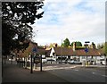
Junction of London Road, Brook Street and Lower High Street, Tring
Image: © Gerald Massey
Taken: 26 Oct 2009
0.02 miles
8
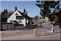
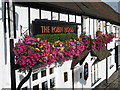
The Robin Hood, Tring
The Robin Hood is a Fuller's pub that stands at the southern end of Brook Street. The building dates from the 16th century.
Image: © Stephen McKay
Taken: 22 Apr 2021
0.02 miles
9
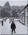
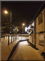
The Robin Hood and snowy footpath
A good fall of snow early on the morning of 8th Feb. 2007 left Tring well covered in snow. This was the footpath next to the Robin Hood P.H. on the corner of Brook Street and High Street, Tring. The figures in the picture are two small Geographers.
Image: © Rob Farrow
Taken: 8 Feb 2007
0.03 miles
10
Robin Hood Pub, Tring
At the corner of the Lower High Street and Brook Street.
Image: © Gerald Massey
Taken: 12 Sep 2009
0.03 miles