IMAGES TAKEN NEAR TO
Bulbourne Road, TRING, HP23 5HF
Introduction
This page details the photographs taken nearby to Bulbourne Road, HP23 5HF by members of the Geograph project.
The Geograph project started in 2005 with the aim of publishing, organising and preserving representative images for every square kilometre of Great Britain, Ireland and the Isle of Man.

There are currently over 7.5m images from over14,400 individuals and you can help contribute to the project by visiting https://www.geograph.org.uk
Image Map
Images are licensed for reuse under creativecommons.org/licenses/by-sa/2.0
Notes
- Clicking on the map will re-center to the selected point.
- The higher the marker number, the further away the image location is from the centre of the postcode.
Image Listing (95 Images Found)
Images are licensed for reuse under creativecommons.org/licenses/by-sa/2.0
Image
Details
Distance
1
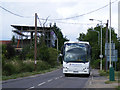
B488 at New Mill
A coach descends the hill on the B488 into New Mill
Image: © David Sands
Taken: 6 Jul 2009
0.02 miles
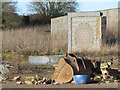
2
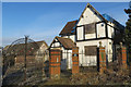
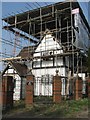
Gamnel Farm, Bulbourne Road, Tring, awaiting demolition
Following the fire three years ago (see Image) planning permission has been requested to allow the farm house and associated buildings to be demolished and two new houses built on the site.
Later Picture: Image
Image: © Chris Reynolds
Taken: 12 Dec 2012
0.03 miles
3
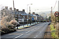
Bulbourne Road, Tring, on a frosty morning
Image: © Chris Reynolds
Taken: 12 Dec 2012
0.03 miles
4
Gamnel Farm, Tring, is no more
The builders have moved onto the site and the old farm house is now a pile of rubble.
See Image
and Image
Image: © Chris Reynolds
Taken: 2 Feb 2014
0.04 miles
5
Gamnel Farm, Bulbourne Road, Tring ? After the fire
Press reports say the farm house was built in 1877, although the name is much older. The fire took place at the end of January 2009 and caused extensive damage, burning its way through the roof. Arson was suspected at the time. It was no longer a farm as and was on the market as a private house, with 20 acres of land and planning permission covering the former farm buildings. In 1901 James Wilkins, farm foreman, was living there with his wife and family.
Late News: For details of arson case see http://www.hemeltoday.co.uk/tring-news/Last-chance-for-arson-teen.5313474.jp
Image: © Chris Reynolds
Taken: 21 Mar 2009
0.05 miles
6
B488 at New Mill
Pargetting on Gamnel farmhouse, now shrouded in scaffolding
Image: © David Sands
Taken: 6 Jul 2009
0.05 miles
7
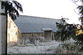
Former Farm Buildings at Gamnel Farm, Bulbourne Road, Tring
See Image
Image: © Chris Reynolds
Taken: 12 Dec 2012
0.05 miles
8
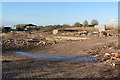
The Former Farmyard of Gamnel Farm, Tring
The site of the old farmyard has been levelled prior to two new houses being built on the site. The flat rectangular area is the floor of an old farm building, which can be seen through the gate in Image
The bricks in the right foreground come from the demolished farmhouse see Image
Note the mosaic wall in the right distance Image
Image: © Chris Reynolds
Taken: 2 Feb 2014
0.05 miles
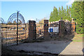
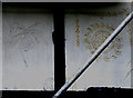
9
Mosaic Wall at back of Gamnel Farm Demolition Site
This feature was not visible from the road before the former farm buildings were demolished Image A look at Google satellite view suggest that it was the backdrop to some water feature with a paved courtyard in front of it.
Image: © Chris Reynolds
Taken: 2 Feb 2014
0.06 miles
10
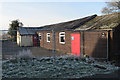
The Former New Mill Social Centre, Tring
This former World War 1 Army Hut (from Gadebridge Camp, Hemel Hempstead) was moved here to become the church of St George, and later the New Mill Social Centre. Planning permission is currently being sought to build houses on the site.
Image: © Chris Reynolds
Taken: 12 Dec 2012
0.08 miles