IMAGES TAKEN NEAR TO
Thomas Gardens, TRING, HP23 5FN
Introduction
This page details the photographs taken nearby to Thomas Gardens, HP23 5FN by members of the Geograph project.
The Geograph project started in 2005 with the aim of publishing, organising and preserving representative images for every square kilometre of Great Britain, Ireland and the Isle of Man.

There are currently over 7.5m images from over14,400 individuals and you can help contribute to the project by visiting https://www.geograph.org.uk
Image Map
Images are licensed for reuse under creativecommons.org/licenses/by-sa/2.0
Notes
- Clicking on the map will re-center to the selected point.
- The higher the marker number, the further away the image location is from the centre of the postcode.
Image Listing (245 Images Found)
Images are licensed for reuse under creativecommons.org/licenses/by-sa/2.0
Image
Details
Distance
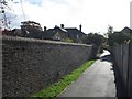
1
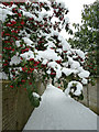
Snowy berries and path
There is a little alley which runs between Mortimer Hill and Station Road linking Tring School to Pound Meadow. It is quite well used as a useful cut-through between the two roads. Here snow covered berries overhang the path ready to drop lumps of the chilly white stuff down the necks of passers by - as I discovered.
Image: © Rob Farrow
Taken: 5 Feb 2012
0.02 miles
2
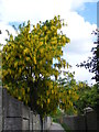
Laburnum near Station Road, Tring
Brightening up a featureless alleyway.
Image: © David Sands
Taken: 28 May 2015
0.02 miles
3
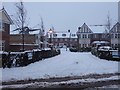
Thomas Gardens, Tring
Thomas Gardens, and the smaller, newer, King Edward Gardens a little further south-west down Mortimer Hill, are so recent that neither yet appear on any online maps [as at December 2017]
They are built on the site of several former houses and their gardens, which were purchased, demolished, and the land built on by Shanly Homes in 2016/2017.
I believe Thomas Gardens is named after a former headmaster of the nearby Tring School, whereas King Edward Gardens are named after King Edward II (reigned 1307-1327) who was king when Tring gained its charter in 1315 (see https://www.geograph.org.uk/snippet/13624 )
Image: © Rob Farrow
Taken: 10 Dec 2017
0.04 miles
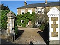
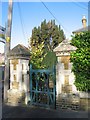
4
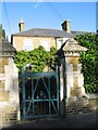
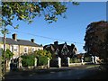
Victorian Gateway, Station Road, Tring
Image: © Gerald Massey
Taken: 23 Oct 2009
0.05 miles
5
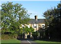
Victorian Villas, Station Road, Tring
For other fine Victorian dwellings on Station Road, see . . . .
Image;
Image;
Image;
Image;
Image;
Image
Image: © Gerald Massey
Taken: 23 Oct 2009
0.06 miles
6
Victorian Villa, Station Road, Tring
For other fine Victorian dwellings on Station Road, see . . . .
Image;
Image;
Image;
Image;
Image;
Image
Image: © Gerald Massey
Taken: 23 Oct 2009
0.06 miles
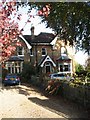
7
Victorian Gateway, Station Road, Tring
Image: © Gerald Massey
Taken: 23 Oct 2009
0.06 miles
9
Victorian Villa, Station Road, Tring
Viewed from the end of the footpath across Pound Meadow. For other fine Victorian dwellings on Station Road, see . . . .
Image;
Image;
Image;
Image;
Image;
Image;
Image
Image: © Gerald Massey
Taken: 23 Oct 2009
0.06 miles
10
Victorian Villas, Station Road, Tring
Viewed from the end of the footpath across Pound Meadow. For other fine Victorian dwellings on Station Road, see . . . .
Image;
Image;
Image;
Image;
Image;
Image
Image: © Gerald Massey
Taken: 23 Oct 2009
0.06 miles