IMAGES TAKEN NEAR TO
Old Airfield Industrial Estate, Cheddington Lane, TRING, HP23 4QR
Introduction
This page details the photographs taken nearby to Old Airfield Industrial Estate, Cheddington Lane, HP23 4QR by members of the Geograph project.
The Geograph project started in 2005 with the aim of publishing, organising and preserving representative images for every square kilometre of Great Britain, Ireland and the Isle of Man.

There are currently over 7.5m images from over14,400 individuals and you can help contribute to the project by visiting https://www.geograph.org.uk
Image Map (Loading...)


Getting Data...Please wait
Leaflet Map data © OpenStreetMap
Images are licensed for reuse under creativecommons.org/licenses/by-sa/2.0
Notes
- Clicking on the map will re-center to the selected point.
- The higher the marker number, the further away the image location is from the centre of the postcode.
Image Listing (4 Images Found)
Images are licensed for reuse under creativecommons.org/licenses/by-sa/2.0
Image
Details
Distance
2
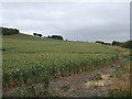
Westend Hill (SW flank)
The Southwestern flank of Westend Hill - full panorama see Image]
Image: © Rob Farrow
Taken: 7 Jul 2010
0.22 miles
3
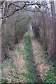
Path to Cheddington
Off Cheddington Lane the path to Cheddington
Image: © Shaun Ferguson
Taken: 17 Jan 2020
0.24 miles
4
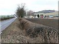
Airfield Industrial Estate, Cheddington
The entrance to the industrial estate lies on Cheddington Lane, and occupies the site of the Marsworth (Cheddington) Airfield, which was used by USAAF in WWII from 1942, flying Liberators and B17 Flying Fortresses. The view looks North East towards Cheddington, and Westend Hill can be seen to the right.
Image: © Chris Cole
Taken: 18 Feb 2006
0.24 miles