IMAGES TAKEN NEAR TO
Longfield Road, TRING, HP23 4DF
Introduction
This page details the photographs taken nearby to Longfield Road, HP23 4DF by members of the Geograph project.
The Geograph project started in 2005 with the aim of publishing, organising and preserving representative images for every square kilometre of Great Britain, Ireland and the Isle of Man.

There are currently over 7.5m images from over14,400 individuals and you can help contribute to the project by visiting https://www.geograph.org.uk
Image Map
Images are licensed for reuse under creativecommons.org/licenses/by-sa/2.0
Notes
- Clicking on the map will re-center to the selected point.
- The higher the marker number, the further away the image location is from the centre of the postcode.
Image Listing (78 Images Found)
Images are licensed for reuse under creativecommons.org/licenses/by-sa/2.0
Image
Details
Distance
3
Barbers Walk, Tring
The street name sign says :-
"To remember Private Edward Barber VC of Tring
1st bn Grenadier Guards
Awarded the Victoria Cross in 1915"
https://en.wikipedia.org/wiki/Edward_Barber
Image: © Des Blenkinsopp
Taken: 23 Sep 2016
0.11 miles
4
St. Martha's Methodist Church, Tring
Image: © Gerald Massey
Taken: 4 Dec 2009
0.12 miles
5

A Snowman in a garden in Miswell Lane, Tring
Quite a lot of houses had strips of fairy lights to celebrate Xmas and sometimes something more elaborate. This house in Miswell Lane chose to have a snowman.
Image: © Chris Reynolds
Taken: 21 Dec 2015
0.12 miles
6
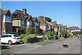
A view along Highfield Road, Tring
This part of the road consists of mid-20th century houses, although there has been some infilling. Unfortunately the black cat didn't prove lucky for the people who lived in the fire-damaged house on the left. Image
Image: © Chris Reynolds
Taken: 10 Sep 2015
0.13 miles
7
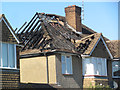
Fire-damaged house in Highfield Road
This fire started in the roof and fortunately no one was hurt. http://www.hemeltoday.co.uk/news/more-news/infamous-glis-glis-is-blamed-for-house-blaze-1-6943894
It is believed that the fire was caused by Glis glis (the edible dormouse https://en.wikipedia.org/wiki/Edible_dormouse ) chewing its way through a cable.
Image: © Chris Reynolds
Taken: 10 Sep 2015
0.13 miles
8
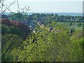
Miswell Lane, Tring from the path to Stubbing's Wood
The footpath from by the A41 bypass bridge on Hastoe Lane to Stubbing's Wood climbs steadily and offers interesting and unusual views over Tring. Here Miswell Lane is seen gently sloping uphill.
See also Image] for another view from near this spot.
Image: © Rob Farrow
Taken: 25 Apr 2020
0.13 miles
9
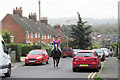
Horse and Rider in Miswell Lane
The houses on the left were built as council houses over 100 years ago.
Car parking in Miswell Lane can cause problems because this a bus route.
Image: © Chris Reynolds
Taken: 23 Oct 2017
0.14 miles
10
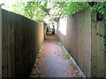
Footpath 48 between Highfield Road and Miswell Lane, Tring
This part of the footpath almost certainly follows the line of the original way over the fields, but is now fenced in so tightly that it is unsuitable for use by bicycles.
Image: © Chris Reynolds
Taken: 29 Sep 2009
0.14 miles