IMAGES TAKEN NEAR TO
Hatton Street, AYLESBURY, HP22 7AL
Introduction
This page details the photographs taken nearby to Hatton Street, HP22 7AL by members of the Geograph project.
The Geograph project started in 2005 with the aim of publishing, organising and preserving representative images for every square kilometre of Great Britain, Ireland and the Isle of Man.

There are currently over 7.5m images from over14,400 individuals and you can help contribute to the project by visiting https://www.geograph.org.uk
Image Map
Images are licensed for reuse under creativecommons.org/licenses/by-sa/2.0
Notes
- Clicking on the map will re-center to the selected point.
- The higher the marker number, the further away the image location is from the centre of the postcode.
Image Listing (38 Images Found)
Images are licensed for reuse under creativecommons.org/licenses/by-sa/2.0
Image
Details
Distance
1
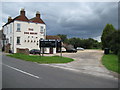
Broughton Crossing: The Dog House
Broughton Crossing got its name from the fact that the London & North Western Railway's Cheddington to Aylesbury branch line crossed over the road here, although there was never a station. Despite that the small community of a public house and about a dozen terraced houses grew up alongside the crossing. The railway was built as long ago as 1839, but was an early pre-Beeching casualty of closure, passenger services having been terminated in 1953 and goods in 1964. The railway ran dead straight from just outside Aylesbury to just outside Cheddington, and it ran here between the silver car and the wheelie bin on the right. The 1926 large scale Ordnance Survey map shows the northern railway boundary fence just clipping the pub outbuilding behind the black sign, while the southern boundary was the hedge on the right.
The public house is now called the Dog House but all the large scale Ordnance Survey maps from 1879 through to 1952 all show it as The Prince of Wales. According to the blackboard the pub also offers en suite accommodation and is the 2008 Good Food Guide. Call 01296 485228 for details...!
Image: © Nigel Cox
Taken: 20 Jul 2008
0.07 miles
2
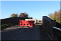
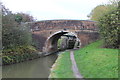
Aylesbury arm bridge 15
Currently closed to traffic
Image: © Robert Eva
Taken: 25 Nov 2016
0.22 miles
3
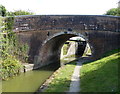
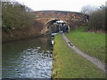
Broughton Lane Bridge No 15
Crossing the Aylesbury Arm of the Grand Union Canal.
The Aylesbury Arm is six and a quarter miles long and has sixteen locks. It runs west from Marsworth Junction to the centre of Aylesbury.
Image: © Mat Fascione
Taken: 16 Aug 2015
0.23 miles
4
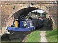
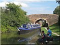
Passing through Lock 14 (14) Leaving the lock and under Bridge 15
The narrowboat emerges from under Bridge 15 on the Aylesbury Arm of the Grand Union Canal.
Note the diagonal brickwork under the bridge arch. This is because the road over the bridge crosses the canal at an angle.
Image
Follow this narrowboat: Image
Next: Image
See also: Image and Image
Image: © Chris Reynolds
Taken: 8 Sep 2009
0.23 miles
5
Passing through Lock 14 (15) Passing under Bridge 15
The narrowboat is clear of the lock, the gates have been closed and the crew are now all on board. Two fishermen watch as the boat start to gather speed on its way to Aylesbury.
Image
Follow this narrowboat: Image
Next: Image
See also: Image
Image: © Chris Reynolds
Taken: 8 Sep 2009
0.23 miles
6
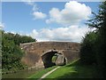
Bridge N? 15, Grand Union Canal, Aylesbury Arm
Image: © Oast House Archive
Taken: 30 Oct 2014
0.23 miles
7
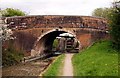
Bridge No 15 over the canal
The Grand Union Canal Aylesbury Arm was completed in 1815 and runs from Marsworth to Aylesbury. This bridge is by Broughton.
Image: © Steve Daniels
Taken: 5 May 2013
0.23 miles
8
Aylesbury Arm: Broughton Lane crosses the Canal (Bridge No 15)
Image: © Chris Reynolds
Taken: 13 Aug 2009
0.23 miles
9
Grand Union Canal
Grand Union Canal Aylesbury Arm at the Broughton Lane bridge with Broughton lock behind
Image: © Shaun Ferguson
Taken: 23 Jan 2009
0.23 miles
10
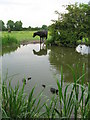
You can lead a horse to water ...
Horse and coots on the Grand Union Canal near Aylesbury.
Image: © Gareth James
Taken: 5 Jun 2010
0.23 miles