IMAGES TAKEN NEAR TO
Dobbins Lane, AYLESBURY, HP22 6DL
Introduction
This page details the photographs taken nearby to Dobbins Lane, HP22 6DL by members of the Geograph project.
The Geograph project started in 2005 with the aim of publishing, organising and preserving representative images for every square kilometre of Great Britain, Ireland and the Isle of Man.

There are currently over 7.5m images from over14,400 individuals and you can help contribute to the project by visiting https://www.geograph.org.uk
Image Map
Images are licensed for reuse under creativecommons.org/licenses/by-sa/2.0
Notes
- Clicking on the map will re-center to the selected point.
- The higher the marker number, the further away the image location is from the centre of the postcode.
Image Listing (3 Images Found)
Images are licensed for reuse under creativecommons.org/licenses/by-sa/2.0
Image
Details
Distance
1
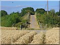
Wendover - Footbridge
Bridge over the A413 and the railway line London-Aylesbury which have just emerged from the Wendover Gap through the Chiltern Hills. Wheat field in the foreground.
Image: © Colin Smith
Taken: 14 Aug 2016
0.19 miles
2
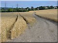
Wendover - Wheat Field
Cereal crop in the southern fringe of the Vale of Aylesbury.
Image: © Colin Smith
Taken: 14 Aug 2016
0.20 miles
3
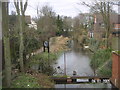
The end (or beginning) of the Wendover Arm of the Grand Union Canal in Wendover
Image: © Dennis Troughton
Taken: 6 Mar 2005
0.21 miles