IMAGES TAKEN NEAR TO
Station Approach, AYLESBURY, HP22 6BN
Introduction
This page details the photographs taken nearby to Station Approach, HP22 6BN by members of the Geograph project.
The Geograph project started in 2005 with the aim of publishing, organising and preserving representative images for every square kilometre of Great Britain, Ireland and the Isle of Man.

There are currently over 7.5m images from over14,400 individuals and you can help contribute to the project by visiting https://www.geograph.org.uk
Image Map
Images are licensed for reuse under creativecommons.org/licenses/by-sa/2.0
Notes
- Clicking on the map will re-center to the selected point.
- The higher the marker number, the further away the image location is from the centre of the postcode.
Image Listing (17 Images Found)
Images are licensed for reuse under creativecommons.org/licenses/by-sa/2.0
Image
Details
Distance
1
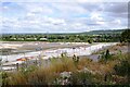
HS2 works at Wendover
A view north from Ellesborough Road of the HS2 works alongside the A413 at Wendover. The line is due to tunnel beneath Ellesborough Road, and to facilitate this four houses have been demolished on the north side of the road.
Image: © Bob Walters
Taken: 30 Aug 2022
0.10 miles
2
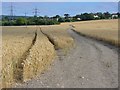
Wendover - Wheat Field
Cereal crop in the southern fringe of the Vale of Aylesbury.
Image: © Colin Smith
Taken: 14 Aug 2016
0.17 miles
3
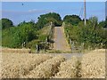
Wendover - Footbridge
Bridge over the A413 and the railway line London-Aylesbury which have just emerged from the Wendover Gap through the Chiltern Hills. Wheat field in the foreground.
Image: © Colin Smith
Taken: 14 Aug 2016
0.18 miles
4
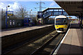
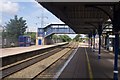
Wendover station. Train to London Marylebone arriving
The old footbridge is in the background. The new one is at the other end of the station.
Image: © Robert Eva
Taken: 15 Feb 2018
0.19 miles
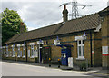
6
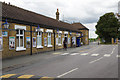
Wendover Station
Wendover station was opened by the Metropolitan Railway in 1892 and, although later on the Great Central Railway's main line north to Sheffield, it continued to be part of the Metropolitan Line until 1961, when London Transport took the decision to pull out of running services beyond Amersham rather than electrifying to Aylesbury. Today it is served by Chiltern Railways trains from Marylebone. This is the main building on Station Approach.
Image: © Stephen McKay
Taken: 4 Jul 2017
0.19 miles
7
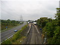
A413 and Wendover Station
Leaving Wendover on the Ridgeway one crosses a long bridge over these two methods of communication that run cheek by jowl with each other - two geographs in one!
Image: © Chris Heaton
Taken: 1 Oct 2007
0.20 miles
9
Wendover station
Wendover is on the line between London (Marylebone) and Aylesbury. It was opened in 1892 by the Metropolitan Railway and in due course became part of the London Transport rail system. It became a British Railways station in 1961 in consequence of London Transport trains being withdrawn north of Amersham and is now part of the Chiltern Railways network.
Image: © David Kemp
Taken: 2 Aug 2009
0.20 miles
10

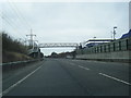
Wendover Station
Wendover station was opened by the Metropolitan Railway in 1892 and, although later on the Great Central Railway's main line north to Sheffield, it continued to be part of the Metropolitan Line until 1961, when London Transport took the decision to pull out of running services beyond Amersham rather than electrifying to Aylesbury. Today it is served by Chiltern Railways trains from Marylebone. To the left is the much newer A413 Wendover by-pass opened in 1998.
Image: © Stephen McKay
Taken: 4 Jul 2017
0.20 miles