IMAGES TAKEN NEAR TO
Drayton Beauchamp, AYLESBURY, HP22 5LU
Introduction
This page details the photographs taken nearby to HP22 5LU by members of the Geograph project.
The Geograph project started in 2005 with the aim of publishing, organising and preserving representative images for every square kilometre of Great Britain, Ireland and the Isle of Man.

There are currently over 7.5m images from over14,400 individuals and you can help contribute to the project by visiting https://www.geograph.org.uk
Image Map (Loading...)


Getting Data...Please wait
Leaflet Map data © OpenStreetMap
Images are licensed for reuse under creativecommons.org/licenses/by-sa/2.0
Notes
- Clicking on the map will re-center to the selected point.
- The higher the marker number, the further away the image location is from the centre of the postcode.
Image Listing (80 Images Found)
Images are licensed for reuse under creativecommons.org/licenses/by-sa/2.0
Image
Details
Distance
1
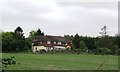
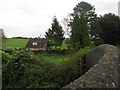
Church Hill Farm, Drayton Beauchamp
This would appear to be currently a private house with no evidence of active farming.
Image: © Chris Reynolds
Taken: 4 May 2009
0.04 miles
2
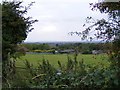
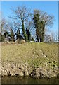
Broadview Farm, the Holloway, Drayton Beauchamp
Viewed from the footpath from the Upper Icknield Way.
Image: © David Sands
Taken: 29 Sep 2007
0.07 miles
3
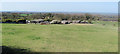
Looking across the field to Broadview Farm, Drayton Beauchamp
This was taken from the stile on the footpath from Tring to Drayton Beauchamp and it seems likely that the path once ran directly across the field towards the farm. However it has been rerouted round the field to the left.
Image: © Chris Reynolds
Taken: 1 Apr 2012
0.12 miles
4

Grand Union Canal (Wendover Arm) in Drayton Beauchamp
This is the downstream end of that section of the canal that currently retains water. Immediately to the north-east of here, and in Image, active restoration works by the Wendover Arm Trust http://www.wendoverarmtrust.co.uk/AboutUs/AboutUs.html are in progress.
The bridge in the distance is Drayton Bridge, while in the foreground a mother moorhen has found a handy plank to stand on while her chicks can stand unsupported on the thin layer of weed on the water surface.
Image: © Nigel Cox
Taken: 2 Aug 2007
0.13 miles
5
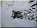
Adolescent Little Grebe fishing at Drayton Beauchamp
Image: © David Sands
Taken: 29 Sep 2007
0.14 miles
6
Bridge Farm, Drayton Beauchamp
A smallholding immediately adjacent to the Wendover Arm of the Grand Union Canal.
Image: © Chris Reynolds
Taken: 4 May 2009
0.14 miles
7
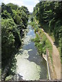
The Wendover Arm looking west from the Bridge at Drayton Beauchamp
This part of the canal was relined when the A41 dual carriageway was built, and vegetation is growing up along the banks and in some places right across the canal. The water runs crystal clear and with plenty of duckweed - but this will change to a muddy soup when canal barges start using it again in a few years time, after a break of over 100 years.
Image: © Chris Reynolds
Taken: 3 Aug 2014
0.14 miles
8
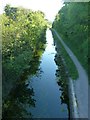
Wendover Arm: Southwest of Drayton Bridge
The Wendover Arm of the Grand Union Canal has been undergoing restoration for many years. The section seen here has not yet been restored to navigation as it does not connect up with the fully restored portion. There is plenty of water in this section however, and looks like it would take little to make it navigable once it is connected up to the rest of the restored canal. The water is, I believe, supplied by springs in the vicinity.
The path seen on the right bank, originally the canal's towpath is now part of the Outer Aylesbury Ring LDP.
The section on the opposite side of the bridge is also in water, though of a more stagnant nature (see Image]).
Image: © Rob Farrow
Taken: 26 Apr 2020
0.14 miles
9
Canal-side bench and trees, Wendover Arm
I'm not sure how one gets to the bench seen perched above the Wendover Arm of the Grand Union canal on the opposite bank, as there seems to be no footpath to it - perhaps it is a private bench belonging to a house in Drayton Beauchamp, or maybe there is an unmarked path leading to it.
Image: © Rob Farrow
Taken: 22 Mar 2015
0.14 miles
10
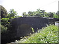
Bridge 5 of the Wendover Arm carrying The Holloway over the canal at Drayton Beauchamp
The Wendover Arm is a part of the Grand Union Canal which was primarily built to supply water for the locks at Marsworth and Cowroast. Construction started in 1793.
Image: © PAUL FARMER
Taken: 1 May 2011
0.14 miles