IMAGES TAKEN NEAR TO
Cublington Road, AYLESBURY, HP22 4RU
Introduction
This page details the photographs taken nearby to Cublington Road, HP22 4RU by members of the Geograph project.
The Geograph project started in 2005 with the aim of publishing, organising and preserving representative images for every square kilometre of Great Britain, Ireland and the Isle of Man.

There are currently over 7.5m images from over14,400 individuals and you can help contribute to the project by visiting https://www.geograph.org.uk
Image Map
Images are licensed for reuse under creativecommons.org/licenses/by-sa/2.0
Notes
- Clicking on the map will re-center to the selected point.
- The higher the marker number, the further away the image location is from the centre of the postcode.
Image Listing (1 Images Found)
Images are licensed for reuse under creativecommons.org/licenses/by-sa/2.0
Image
Details
Distance
1
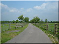
Access Road
This lane provides access to several fields between Willowbrook, Longmoor & Norduck Farms, all just outside Aston Abbots. (Willowbrook Farm being on the Whitchurch - Cublington Road)
Image: © Mr Biz
Taken: 22 May 2008
0.20 miles