1
The road north out of Whitchurch, present and former
The present-day A413 heads north to Buckingham on the right. The road formerly followed the route of the track to the left of the bench and bin.
Image: © HelenK
Taken: 27 Dec 2010
0.04 miles
2
A413 towards Buckingham
Leaving Whitchurch.
Image: © Robin Webster
Taken: 9 Jun 2019
0.04 miles
3
House by A413 at Whitchurch
View across the main Aylesbury-Buckingham road at the northern edge of Whitchurch. The road opposite is Mount Pleasant, and has Rickyard Close off it.
Image: © David Hawgood
Taken: 12 May 2007
0.05 miles
4
Lane in Whitchurch
This lane runs parallel to the main A413 on the left and Rickyard Close on the right. It is a surprise to find a country lane sandwiched between a main road and a new housing estate. The lane is less than 100 metres long.
Image: © David Hawgood
Taken: 12 May 2007
0.08 miles
5
Rickyard Close, Whitchurch
This new housing development is at the north end of the village, with Mount Pleasant curving around it.
Image: © David Hawgood
Taken: 12 May 2007
0.08 miles
6
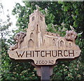
Village sign, "Whitchurch 2000 AD"
This sign put up to celebrate the new millennium is a wooden carving of the church of St John the Evangelist.
Image: © David Hawgood
Taken: 12 May 2007
0.09 miles
7
Roundabout on Buckingham Road, Whitchurch
Image: © David Howard
Taken: 4 Feb 2018
0.10 miles
8
George VI postbox at the top of Market Hill
Image: © Philip Jeffrey
Taken: 1 Aug 2013
0.14 miles
9
Thatched Cottage, Whitchurch
An oddly shaped cottage situated in the angle between High Street (to the right), Market Hill (to the left) and Oving Road (behind). Note the spider woven into the thatch.
Image: © Chris Cole
Taken: 10 Mar 2006
0.14 miles
10
Whitchurch Manor House?
In the centre of Whitchurch is this once great mansion. The village has several other smaller properties of a similar age. Its size suggests this is/was Whitchurch Manor House occupied by the Earls of Oxford and then the Waterhouse family during the 16th century, and by the Pauley, Blackwell and Smythe families in the 17th, among many other tenants - see http://www.british-history.ac.uk/report.aspx?compid=42596#s4
Image: © D Gore
Taken: Unknown
0.14 miles


