IMAGES TAKEN NEAR TO
Moat Lane, AYLESBURY, HP22 4NE
Introduction
This page details the photographs taken nearby to Moat Lane, HP22 4NE by members of the Geograph project.
The Geograph project started in 2005 with the aim of publishing, organising and preserving representative images for every square kilometre of Great Britain, Ireland and the Isle of Man.

There are currently over 7.5m images from over14,400 individuals and you can help contribute to the project by visiting https://www.geograph.org.uk
Image Map (Loading...)


Getting Data...Please wait
Leaflet Map data © OpenStreetMap
Images are licensed for reuse under creativecommons.org/licenses/by-sa/2.0
Notes
- Clicking on the map will re-center to the selected point.
- The higher the marker number, the further away the image location is from the centre of the postcode.
Image Listing (61 Images Found)
Images are licensed for reuse under creativecommons.org/licenses/by-sa/2.0
Image
Details
Distance
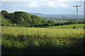
2
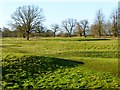
Pasture with earthworks, Aston Abbotts
This field contains many earthworks, possibly remnants of human habitation following the emparkment of the land.
Image: © Andrew Smith
Taken: 24 Jan 2015
0.10 miles
3
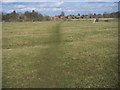
The footpath to Aston Abbotts
From The Lines the footpath to Aston Abbotts
Image: © Shaun Ferguson
Taken: 1 Mar 2010
0.13 miles
7
Former Independent Chapel, Aston Abbotts
This Independent Chapel was built in 1839. On the 1851 ecclesiastical census it is described as an "Independent and Baptist Chapel" and the attendance, on the 30th March that year, was 120 in the morning including 17 Sunday Scholars. A further 17 attended in the afternoon and 19 in the evening.
It would appear that it has now been converted into family homes.
Image: © Rob Farrow
Taken: 7 Sep 2006
0.14 miles
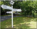
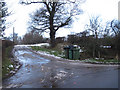
10
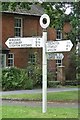
Old Direction Sign - Signpost by The Green, Aston Abbotts Parish
Annulus finial - 3 arms; Bucks County halo by the UC road, in parish of Aston Abbotts (Aylesbury Vale District), The Green, on grass triangle.
Surveyed
Milestone Society National ID: BU_SP8420
Image: © Milestone Society
Taken: Unknown
0.17 miles