IMAGES TAKEN NEAR TO
Wickham Field, AYLESBURY, HP22 4FR
Introduction
This page details the photographs taken nearby to Wickham Field, HP22 4FR by members of the Geograph project.
The Geograph project started in 2005 with the aim of publishing, organising and preserving representative images for every square kilometre of Great Britain, Ireland and the Isle of Man.

There are currently over 7.5m images from over14,400 individuals and you can help contribute to the project by visiting https://www.geograph.org.uk
Image Map
Images are licensed for reuse under creativecommons.org/licenses/by-sa/2.0
Notes
- Clicking on the map will re-center to the selected point.
- The higher the marker number, the further away the image location is from the centre of the postcode.
Image Listing (30 Images Found)
Images are licensed for reuse under creativecommons.org/licenses/by-sa/2.0
Image
Details
Distance
2
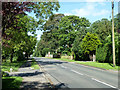
Leighton Road, Wingrave
Lined with a linear extension of the old village on the road towards Leighton Buzzard.
Image: © Robin Webster
Taken: 5 Jun 2014
0.10 miles
3
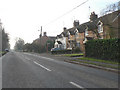
Cottages on Leighton Road
View South West down Leighton Road towards Wingrave
Image: © Chris Cole
Taken: 24 Jan 2006
0.11 miles
4
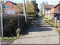
Footpath off Leighton Road
Footpath off Leighton Road heads up between the houses
Image: © Shaun Ferguson
Taken: 1 Mar 2010
0.18 miles
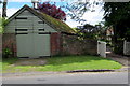
6
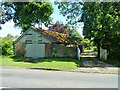
Garage or barn, Windmill House, Wingrave
Unfortunately since this 2014 view it has been rebuilt or renovated. This caused the loss of the interesting roof vent and the upper level end doors.
Image: © Robin Webster
Taken: 5 Jun 2014
0.19 miles
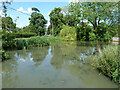
8

Ducks on the Pond
Wingrave pond on an October afternoon.
Image: © Des Blenkinsopp
Taken: 29 Oct 2019
0.21 miles

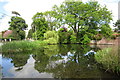
10
Village pond, Wingrave
One each of Moorhen, Coot and Mallard are visible.
Image: © Robin Webster
Taken: 5 Jun 2014
0.21 miles