IMAGES TAKEN NEAR TO
Weir Lane, AYLESBURY, HP22 4EP
Introduction
This page details the photographs taken nearby to Weir Lane, HP22 4EP by members of the Geograph project.
The Geograph project started in 2005 with the aim of publishing, organising and preserving representative images for every square kilometre of Great Britain, Ireland and the Isle of Man.

There are currently over 7.5m images from over14,400 individuals and you can help contribute to the project by visiting https://www.geograph.org.uk
Image Map (Loading...)


Getting Data...Please wait
Leaflet Map data © OpenStreetMap
Images are licensed for reuse under creativecommons.org/licenses/by-sa/2.0
Notes
- Clicking on the map will re-center to the selected point.
- The higher the marker number, the further away the image location is from the centre of the postcode.
Image Listing (122 Images Found)
Images are licensed for reuse under creativecommons.org/licenses/by-sa/2.0
Image
Details
Distance
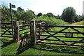
1
Bolebec footpath
Weir Lane runs North-South to the west of Whitchurch, this footpath strikes off to the SSE skirting the southern and eastern flanks of Image
Image: © Rob Farrow
Taken: 13 Oct 2006
0.01 miles
2
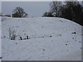
Bolebec Castle mound
In snowy weather the north side of the mound makes a good short toboggan run.
Image: © HelenK
Taken: 27 Dec 2010
0.02 miles
3
Bolebec Castle mound
This is the mound of the ancient Bolebec Castle built originally by Hugh de Bolebec in the twelfth century. Part of the castle's old moat can be seen in Image This photograph was taken (appropriately enough) from Castle Lane near its junction with Weir Lane. More information on the castle can be found here http://www.british-history.ac.uk/report.asp?compid=42596#s2
Image: © Rob Farrow
Taken: 13 Oct 2006
0.03 miles
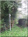
4
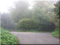
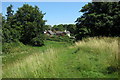
Lanes diverge
Taken from the southern section of Weir Lane looking north, this lane continues to the left while Castle Lane diverges to the right. Weir Lane divides the two possible sites for the ancient Bolebec Castle - To the right (East) here is the Image] while to the left in a field is Image]
Image: © Rob Farrow
Taken: 13 Oct 2006
0.04 miles
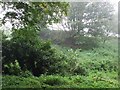
6
Bolebec Castle, Moat and Spring
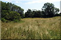
The OS maps are a little schizophrenic as to which side of the road Bolebec Castle was situated - though probably it spread over both named sites. On the opposite side is Image] which was clearly a castle mound. On this side there is this curious circular wooded enclosure. It contains a small pool which can be glimpsed if you get closer (see Image]), and according to the modern maps there is a spring here. On the 1940s map this is given as an ancient moat however. Whatever its antecedents however it was a quite remarkably atmospheric place, perhaps magnified by the swirling mist on my visit.
[Edit] Information from the link below suggests that this pond is known as Weir Pond and is indeed part of the old moat of the castle.
More information about Bolebec Castle here http://www.british-history.ac.uk/report.asp?compid=42596#s2
Image: © Rob Farrow
Taken: 13 Oct 2006
0.04 miles
7
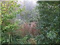
Enclosed pool or moat
This is a close-up of the enclosed area where Bolebec Castle may once have stood (see Image]) The trees encircled a pool which may once have been the castle's moat. According to the map there is a spring here too. See also Image]
Image: © Rob Farrow
Taken: 13 Oct 2006
0.04 miles
8
Top of the castle mound
On the site of Bolbec Castle
Image: © Philip Jeffrey
Taken: 1 Aug 2013
0.05 miles
9
View into moat ditch from the castle mound
Image: © Philip Jeffrey
Taken: 1 Aug 2013
0.05 miles