IMAGES TAKEN NEAR TO
Dunton Road, AYLESBURY, HP22 4EL
Introduction
This page details the photographs taken nearby to Dunton Road, HP22 4EL by members of the Geograph project.
The Geograph project started in 2005 with the aim of publishing, organising and preserving representative images for every square kilometre of Great Britain, Ireland and the Isle of Man.

There are currently over 7.5m images from over14,400 individuals and you can help contribute to the project by visiting https://www.geograph.org.uk
Image Map
Images are licensed for reuse under creativecommons.org/licenses/by-sa/2.0
Notes
- Clicking on the map will re-center to the selected point.
- The higher the marker number, the further away the image location is from the centre of the postcode.
Image Listing (5 Images Found)
Images are licensed for reuse under creativecommons.org/licenses/by-sa/2.0
Image
Details
Distance
1
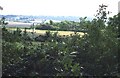
Countryside near Hartwell Hill Farm
The lane to Dunton from the A413 just cuts the NW corner of this gridsquare. This view is taken from that lane looking SE across the entire gridsquare, which is open countryside and farmland.
Image: © Rob Farrow
Taken: 7 Sep 2006
0.02 miles
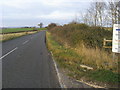
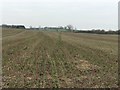
2
Farmland, Creslow
Beside the footpath below Hartwell Hill Farm.
Image: © Andrew Smith
Taken: 24 Jan 2015
0.16 miles
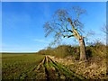
3
Hartwell Hill Farm seen across wheat field
View from road to Dunton.
Image: © David Hawgood
Taken: 12 May 2007
0.17 miles
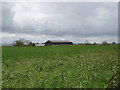
4
Road to Dunton
Road to Dunton by Hartwell Hill Farm
Image: © Shaun Ferguson
Taken: 12 Nov 2011
0.21 miles
5
Path to Dunton
From Creslow the path to Dunton heads to go below Hartwell Hill Farm
Image: © Shaun Ferguson
Taken: 4 Jan 2019
0.24 miles