IMAGES TAKEN NEAR TO
Creslow, AYLESBURY, HP22 4EH
Introduction
This page details the photographs taken nearby to HP22 4EH by members of the Geograph project.
The Geograph project started in 2005 with the aim of publishing, organising and preserving representative images for every square kilometre of Great Britain, Ireland and the Isle of Man.

There are currently over 7.5m images from over14,400 individuals and you can help contribute to the project by visiting https://www.geograph.org.uk
Image Map (Loading...)


Getting Data...Please wait
Leaflet Map data © OpenStreetMap
Images are licensed for reuse under creativecommons.org/licenses/by-sa/2.0
Notes
- Clicking on the map will re-center to the selected point.
- The higher the marker number, the further away the image location is from the centre of the postcode.
Image Listing (7 Images Found)
Images are licensed for reuse under creativecommons.org/licenses/by-sa/2.0
Image
Details
Distance
1
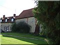
The Old Chapel, Creslow
This chapel is marked on the map and edged in black suggesting it is a public building, but it looks to me as though it has been incorporated into the adjoining building. The only signs were ones informing that there was no right of way for the public - so at best it probably has a very small congregation !
Edit: According to the English Heritage Viewfinder website "The former parish church, which ceased being used in the 18th century, was first a dovecot and is now used as an outbuilding of the Manor House. " ( See http://viewfinder.english-heritage.org.uk/search/detail.aspx?uid=51561 )
However the BHO website (see http://www.british-history.ac.uk/report.aspx?compid=42572&strquery=Parish%20Creslow#s3 ) itself quoting the "History of the County of Buckingham" suggests that it had not been used as a church since the time of Elizabeth I (1558-1603). A list of the rectors (see http://met.open.ac.uk/genuki/big/eng/BKM/Creslow/rectors.html ) finishes with the appointment of Thomas Davis A.M. in 1554 - which serves to confirm this earlier date.
Image: © Rob Farrow
Taken: 7 Sep 2006
0.04 miles
2
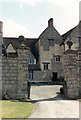
Creslow Chapel
Now incorporated as part of the Manor. This entire site was once part of a military base.
Image: © Mr Biz
Taken: 20 Jul 2008
0.05 miles
3
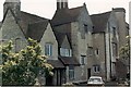
Creslow Manor House and its history
Creslow was a 14th century manor owned by the Knights Hospitallers until the dissolution of the monasteries. Until the Civil War the Manor House was the home of the Keeper of the Royal Pastures (about 900 acres) where high quality food, mainly beasts, for the King’s household were raised. The present house is one of the oldest surviving domestic buildings in England, a fascinating combination of periods. At its heart is a house of the early 14th century (circa 1330) with walls of squared limestone six feet thick. Among other features, it has a 14th century vaulted crypt, built with stone finely groined and about 12 foot square – now used as a cellar. Ref:: Royal Commission on Historical Monuments - Bucks (Creslow) 1911. See also http://www.british-history.ac.uk/report.aspx?compid=42572&strquery=Parish%20Creslow#s1
In the early 17th century the Keeper of the Royal Pastures (and therefore also an Officer of the King’s Household) was Joseph Mayne of the nearby Hoggeston family Image When he became Sergeant at Arms to the Lord Treasurer, he was followed at Creslow by his son Edward. In 1635 King Charles I took pity on one Cornelius Holland, a young man at court whose father had been imprisoned for debt, and made him the Keeper at Creslow. But come the Civil War, Cornelius repaid his benefactor by being one of those who signed the King’s death warrant in 1649. With the restoration of the monarchy in 1660, Cornelius was attainted for high treason and fled the country. Edward Mayne unsuccessfully applied to replace him but it went elsewhere – see http://www.british-history.ac.uk/report.aspx?compid=42572&strquery=Parish%20Creslow#s2
Image: © D Gore
Taken: Unknown
0.09 miles
5
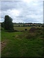
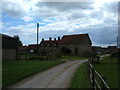
Public Footpath
Standing just to the side of this track, it can be seen going round the treeline in the next field. This was taken just outside Creslow looking towards Whitchurch, which can be seen in the distance.
Image: © Mr Biz
Taken: 20 Jul 2008
0.17 miles
6
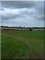
Public Footpath
Running from Creslow to Dunton, the path is visible through the fields. Hartwell Hill Farm is on the horizon.
Image: © Mr Biz
Taken: 20 Jul 2008
0.18 miles
7
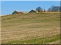
Farmland, Creslow
A field of stubble below the hamlet, which is what remains of a destered mediaeval village, now dominated by some large modern farm buildings.
Image: © Andrew Smith
Taken: 24 Jan 2015
0.24 miles