IMAGES TAKEN NEAR TO
Station Road, AYLESBURY, HP22 4BT
Introduction
This page details the photographs taken nearby to Station Road, HP22 4BT by members of the Geograph project.
The Geograph project started in 2005 with the aim of publishing, organising and preserving representative images for every square kilometre of Great Britain, Ireland and the Isle of Man.

There are currently over 7.5m images from over14,400 individuals and you can help contribute to the project by visiting https://www.geograph.org.uk
Image Map
Images are licensed for reuse under creativecommons.org/licenses/by-sa/2.0
Notes
- Clicking on the map will re-center to the selected point.
- The higher the marker number, the further away the image location is from the centre of the postcode.
Image Listing (10 Images Found)
Images are licensed for reuse under creativecommons.org/licenses/by-sa/2.0
Image
Details
Distance
1
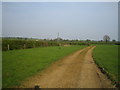
Footpath near Quainton
This short footpath looking east links Station Road south of the village of Quainton and behind the camera with a north-south footpath that crosses the photo just beyond the bend. This second footpath is also on the route of the both the North Buckinghamshire Way and the Midshires Way.
Image: © Andy Gryce
Taken: 21 Apr 2007
0.11 miles
2
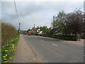
Station Road, Quainton
Houses of varying styles and sizes line the east side of the road towards Quainton, daffodils the west.
Image: © E Gammie
Taken: 3 Apr 2011
0.13 miles
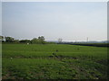
5
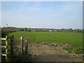
Field and footpath near Quainton
The footpath is the North Buckinghamshire Way and the Midshires Way, and the village of Quainton is to the left and in the middle distance. The Quainton windmill, the tallest in Buckinghamshire, can also be seen in the distance in the direction of the footpath.
Image: © Andy Gryce
Taken: 21 Apr 2007
0.20 miles
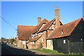
6

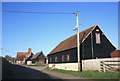
Station Road Farm, Quainton
Tarred weatherboarding and timber framing with plain brick infill are typical of the area.
Image: © Alan Murray-Rust
Taken: 23 Aug 2008
0.20 miles
7
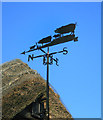
Weather Pigs
Yet another variation.
Located on the centre building in this shot Image
Image: © Des Blenkinsopp
Taken: 10 Mar 2015
0.20 miles
9
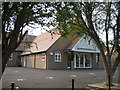
Quainton Memorial Hall, Station Road, Quainton
This modern village hall, which is about 100m from The Green, the centre of Quainton, was opened in October 2005, the cost being met by public subscriptions, fund raising events, and grants from numerous charities including £196,700 from the National Lottery Community Fund. This building replaced the original Memorial Hall which opened in 1924 on the same site, and which was built in remembrance to the 23 men of Quainton lost in the 1914-18 war. In the 1939-45 war, a further 3 men were lost. The hall remains a memorial to those who died in military service, and the commemoration plaques have been re-instated in the new building.
Image: © Andy Gryce
Taken: 29 Apr 2007
0.23 miles
10
Field and footpath near Quainton
The footpath, which does not look well trodden, goes to Waddesdon, and on the OS 1:25,000 is marked as both the North Buckinghamshire Way and the Midshires Way.
Image: © Andy Gryce
Taken: 21 Apr 2007
0.23 miles