IMAGES TAKEN NEAR TO
Brill, AYLESBURY, HP18 9XA
Introduction
This page details the photographs taken nearby to HP18 9XA by members of the Geograph project.
The Geograph project started in 2005 with the aim of publishing, organising and preserving representative images for every square kilometre of Great Britain, Ireland and the Isle of Man.

There are currently over 7.5m images from over14,400 individuals and you can help contribute to the project by visiting https://www.geograph.org.uk
Image Map
Images are licensed for reuse under creativecommons.org/licenses/by-sa/2.0
Notes
- Clicking on the map will re-center to the selected point.
- The higher the marker number, the further away the image location is from the centre of the postcode.
Image Listing (3 Images Found)
Images are licensed for reuse under creativecommons.org/licenses/by-sa/2.0
Image
Details
Distance
2
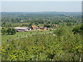
Corble Farm, near Piddington
Photo from Muswell Hill
Image: © David Hawgood
Taken: 3 Jun 2006
0.18 miles
3
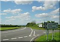
Muswell Hill road junction (with B4011)
This view facing NW is of the junction at the bottom of the steep Muswell Hill road. Here, it meets the B4011 approx halfway between Bicester and Thame. This corner in particular is famous for being a motor accident blackspot, due to the often obscured view at corners, which are particularly lethal in wet conditions. The steep gradients do not help either. The road ahead leads to Blackthorn and Bicester.
Image: © Kurt C
Taken: 29 Jul 2007
0.19 miles