IMAGES TAKEN NEAR TO
Oakley Road, AYLESBURY, HP18 9SH
Introduction
This page details the photographs taken nearby to Oakley Road, HP18 9SH by members of the Geograph project.
The Geograph project started in 2005 with the aim of publishing, organising and preserving representative images for every square kilometre of Great Britain, Ireland and the Isle of Man.

There are currently over 7.5m images from over14,400 individuals and you can help contribute to the project by visiting https://www.geograph.org.uk
Image Map
Images are licensed for reuse under creativecommons.org/licenses/by-sa/2.0
Notes
- Clicking on the map will re-center to the selected point.
- The higher the marker number, the further away the image location is from the centre of the postcode.
Image Listing (6 Images Found)
Images are licensed for reuse under creativecommons.org/licenses/by-sa/2.0
Image
Details
Distance
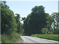
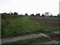
1
The road to Brill passes Hillside Farm
Image: © Steve Daniels
Taken: 2 Mar 2015
0.02 miles
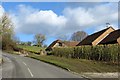
2
Hillside Farm
Hillside farm with Brill in the distance
Image: © Bill Nicholls
Taken: 15 Apr 2015
0.06 miles
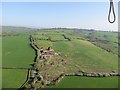
4
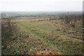
Hillside near Nashway Farm
A dull wet December day has restricted the view. You can see down to the houses of Oakley. The discarded cans in the foreground are evidence of the nearby track where cars can stop.
Image: © Bill Boaden
Taken: 27 Dec 2022
0.16 miles
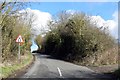
5
By Nashway farm
Footpath by Nashway farm looking down hedge to bridleway by tree line.
Image: © Shaun Ferguson
Taken: 28 Sep 2008
0.21 miles