IMAGES TAKEN NEAR TO
Thame Road, AYLESBURY, HP18 9SG
Introduction
This page details the photographs taken nearby to Thame Road, HP18 9SG by members of the Geograph project.
The Geograph project started in 2005 with the aim of publishing, organising and preserving representative images for every square kilometre of Great Britain, Ireland and the Isle of Man.

There are currently over 7.5m images from over14,400 individuals and you can help contribute to the project by visiting https://www.geograph.org.uk
Image Map
Images are licensed for reuse under creativecommons.org/licenses/by-sa/2.0
Notes
- Clicking on the map will re-center to the selected point.
- The higher the marker number, the further away the image location is from the centre of the postcode.
Image Listing (3 Images Found)
Images are licensed for reuse under creativecommons.org/licenses/by-sa/2.0
Image
Details
Distance
1
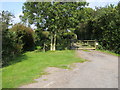
Bridleway by Leatherslade farm
Bridleway by Leatherslade farm where the Great Train Robbers hid out in 1963
Image: © Shaun Ferguson
Taken: 28 Sep 2008
0.03 miles
2
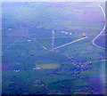
Former RAF Oakley from the air
The village of Oakley is to the lower right, with the M40 motorway visible to the top right. Click on this http://en.wikipedia.org/wiki/RAF_Oakley to go to the wikipedia article about the base. Viewed from a Heathrow bound flight from Glasgow.
Image: © Thomas Nugent
Taken: 10 Apr 2011
0.10 miles
3
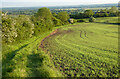
Farmland, Brill
Spring-sown cereal beside the bridleway dropping to Leatherslade Farm.
Image: © Andrew Smith
Taken: 20 May 2023
0.11 miles