IMAGES TAKEN NEAR TO
The Avenue, AYLESBURY, HP18 9LE
Introduction
This page details the photographs taken nearby to The Avenue, HP18 9LE by members of the Geograph project.
The Geograph project started in 2005 with the aim of publishing, organising and preserving representative images for every square kilometre of Great Britain, Ireland and the Isle of Man.

There are currently over 7.5m images from over14,400 individuals and you can help contribute to the project by visiting https://www.geograph.org.uk
Image Map
Images are licensed for reuse under creativecommons.org/licenses/by-sa/2.0
Notes
- Clicking on the map will re-center to the selected point.
- The higher the marker number, the further away the image location is from the centre of the postcode.
Image Listing (33 Images Found)
Images are licensed for reuse under creativecommons.org/licenses/by-sa/2.0
Image
Details
Distance
1
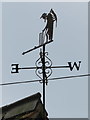
Father time on Worminghall Village Hall
This Father Time weather vane on the village hall seems to be a replica, or at least a copy of the 1926 one at Lords cricket ground. I don't know why it adorns this building, but there was a village cricket team in the 19th century, so perhaps there still is one?
Image: © John S Turner
Taken: 27 May 2016
0.06 miles
2
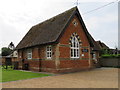
Worminghall Village Hall
Worminghall Village Hall used to be the village school. A school existed in Worminghall as far back as the 1820s, set up by Viscountess Clifden, but I don't know if it was in this building. There is an Ordnance Survey bench mark on the corner of the building nearest the camera - Image
Image: © John S Turner
Taken: 27 May 2016
0.06 miles
3
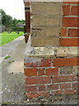
Bench mark on Worminghall Village Hall
This Ordnance Survey bench mark is on the west face of the north west corner of the village hall. Originally the building was the village school. See also Image
Image: © John S Turner
Taken: 27 May 2016
0.06 miles
5
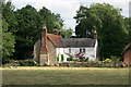
Old house in the middle of Worminghall
Worminghall village is sort of horseshoe shaped, with a handful of small fields and farm buildings in the centre surrounded by housing on three sides.
Image: © Des Blenkinsopp
Taken: 21 Jul 2015
0.08 miles
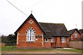
6
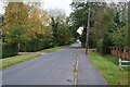
The Avenue, Worminghall
Providing access to the parish church, a couple of farms and numerous houses. The village hall is at the end of this straight.
Image: © Bill Boaden
Taken: 23 Oct 2011
0.09 miles
7
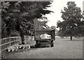
Sleepy Sheep
A bit of a doze on a hot day.
In Worminghall, housing and farming seem a bit more mixed together than in many places. There are fields of livestock more or less in the centre of the village.
Image: © Des Blenkinsopp
Taken: 21 Jul 2015
0.10 miles
8
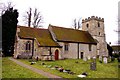
St. Peter and St. Paul's Church in Worminghall
Image: © Steve Daniels
Taken: 13 Feb 2010
0.14 miles
9
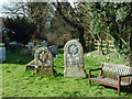
Graves with stars of David, Worminghall
Apparently the symbol has not been exclusive to Judaism, but they are a surprising sight in a Church of England village graveyard. These are definitely Christian as they have superimposed 'IHS' monograms.
Image: © Robin Webster
Taken: 22 Feb 2014
0.14 miles
10
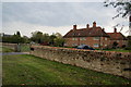
Almshouses in Worminghall
Grade II listed buildings.
Image: © Bill Boaden
Taken: 23 Oct 2011
0.14 miles