IMAGES TAKEN NEAR TO
Brandy Street, AYLESBURY, HP18 0YN
Introduction
This page details the photographs taken nearby to Brandy Street, HP18 0YN by members of the Geograph project.
The Geograph project started in 2005 with the aim of publishing, organising and preserving representative images for every square kilometre of Great Britain, Ireland and the Isle of Man.

There are currently over 7.5m images from over14,400 individuals and you can help contribute to the project by visiting https://www.geograph.org.uk
Image Map
Images are licensed for reuse under creativecommons.org/licenses/by-sa/2.0
Notes
- Clicking on the map will re-center to the selected point.
- The higher the marker number, the further away the image location is from the centre of the postcode.
Image Listing (24 Images Found)
Images are licensed for reuse under creativecommons.org/licenses/by-sa/2.0
Image
Details
Distance
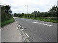
2
View from lay-by off A41 looking north towards Quarrendon
Image: © Jon S
Taken: 26 Sep 2005
0.08 miles
3
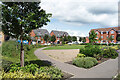
A bit of a garden
Open space among the houses.
Image: © Des Blenkinsopp
Taken: 5 Jul 2021
0.10 miles
4
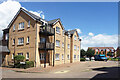
New Housing on Moorcroft Lane
Another part of the extensive new developments around here.
Moorcroft Lane sounds rather rural, but as you see, it's definitely urban.
Image: © Des Blenkinsopp
Taken: 5 Jul 2021
0.12 miles
5
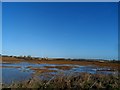
Development land, Aylesbury
A large roundabout with chevron bricks is waiting for the first errant driver to make a mess of it.
Photo location may need amending when mapping updated.
Image: © Michael Trolove
Taken: 30 Dec 2012
0.13 miles
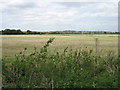
6
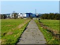
New footpath across pasture, Quarrendon
It seems a shame to have tarmacked across a deserted mediaeval village. The tarmac ends at the end of this field and it is then a struggle to find a way round the next field and onto the road. The buildings in the background are a new school, part of much new development on the northern edge of Aylesbury.
Image: © Andrew Smith
Taken: 2 Jan 2015
0.17 miles

8
Land ready for new housing development
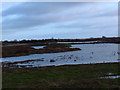
See Michael Trolove's picture from late 2012 http://www.geograph.org.uk/photo/3276714 when the roads were still being constructed. There seems to be a lot of standing water on this site and it is clearly in the flood plain of the river.
Image: © Bikeboy
Taken: 2 Jan 2015
0.20 miles

10
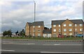
New housing development by the A41, Quarrendon
Image: © David Howard
Taken: 11 Oct 2020
0.20 miles