IMAGES TAKEN NEAR TO
Edgcott Road, AYLESBURY, HP18 0SZ
Introduction
This page details the photographs taken nearby to Edgcott Road, HP18 0SZ by members of the Geograph project.
The Geograph project started in 2005 with the aim of publishing, organising and preserving representative images for every square kilometre of Great Britain, Ireland and the Isle of Man.

There are currently over 7.5m images from over14,400 individuals and you can help contribute to the project by visiting https://www.geograph.org.uk
Image Map
Images are licensed for reuse under creativecommons.org/licenses/by-sa/2.0
Notes
- Clicking on the map will re-center to the selected point.
- The higher the marker number, the further away the image location is from the centre of the postcode.
Image Listing (7 Images Found)
Images are licensed for reuse under creativecommons.org/licenses/by-sa/2.0
Image
Details
Distance
4
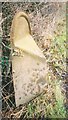
Old Milepost north of Grendon Underwood
Pressed steel post by the UC road, in parish of Grendon Underwood (Aylesbury Vale District), Edgcott Road; near Hall Cottages, North of parish church, in hedge on very narrow drive, on West side of road. Bucks pressing, erected by the County Council in the 20th century.
Inscription once read:-
: (BRILL / 7) : : (BUCKINGHAM / 9) :
Buckinghamshire HER.
HER Number: 1356100000 https://www.heritagegateway.org.uk/Gateway/Results_Single.aspx?uid=MBC25690&resourceID=1024
Milestone Society National ID: BU_BRBU07
Image: © A Rosevear & J Higgins
Taken: 3 Mar 2003
0.06 miles
5
Springhill Road on the Springhill Prison Estate
Image: © John Firth
Taken: 29 Oct 2014
0.20 miles
7
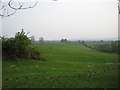
Mill Hill and Spring Hill near Grendon Underwood
Mill Hill is in the centre middle distance, and the slightly higher ground to the left is Spring Hill (marked on the OS 1:25,000 map) at 96m. Spring Hill gives its name to HM Prison Springhill which is behind the camera. The village of Grendon Underwood is in the far distance to the right.
Image: © Andy Gryce
Taken: 29 Apr 2007
0.21 miles