IMAGES TAKEN NEAR TO
Bicester Road, AYLESBURY, HP18 0RA
Introduction
This page details the photographs taken nearby to Bicester Road, HP18 0RA by members of the Geograph project.
The Geograph project started in 2005 with the aim of publishing, organising and preserving representative images for every square kilometre of Great Britain, Ireland and the Isle of Man.

There are currently over 7.5m images from over14,400 individuals and you can help contribute to the project by visiting https://www.geograph.org.uk
Image Map
Images are licensed for reuse under creativecommons.org/licenses/by-sa/2.0
Notes
- Clicking on the map will re-center to the selected point.
- The higher the marker number, the further away the image location is from the centre of the postcode.
Image Listing (6 Images Found)
Images are licensed for reuse under creativecommons.org/licenses/by-sa/2.0
Image
Details
Distance
1
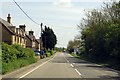
The A41 runs through Kingswood
The A41 follows the Roman road, Akeman Street.
Image: © Steve Daniels
Taken: 4 May 2014
0.13 miles
2
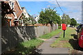
Footpath to A41
The footpath to the A41 cuts to the right of the thatched cottage
Image: © Shaun Ferguson
Taken: 31 Oct 2009
0.14 miles
3
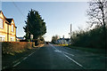
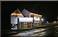
A41 towards Aylesbury
Kingswood, with The Canaletto restaurant and pub ahead on the right, flying an Italian flag.
Image: © Robin Webster
Taken: 28 Dec 2017
0.20 miles
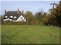
5
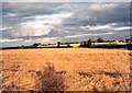
Upper Tetchwick Farm
Making hay whilst the sun shines at Upper Tetchwick Farm. Looking east
Image: © Paul Derwent
Taken: 29 Aug 2002
0.20 miles