IMAGES TAKEN NEAR TO
Sharps Close, AYLESBURY, HP18 0NA
Introduction
This page details the photographs taken nearby to Sharps Close, HP18 0NA by members of the Geograph project.
The Geograph project started in 2005 with the aim of publishing, organising and preserving representative images for every square kilometre of Great Britain, Ireland and the Isle of Man.

There are currently over 7.5m images from over14,400 individuals and you can help contribute to the project by visiting https://www.geograph.org.uk
Image Map
Images are licensed for reuse under creativecommons.org/licenses/by-sa/2.0
Notes
- Clicking on the map will re-center to the selected point.
- The higher the marker number, the further away the image location is from the centre of the postcode.
Image Listing (24 Images Found)
Images are licensed for reuse under creativecommons.org/licenses/by-sa/2.0
Image
Details
Distance
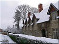
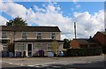
1
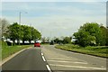
Goss Avenue at the junction of High Street Waddesdon
Image: © David Howard
Taken: 8 Jun 2019
0.04 miles
2
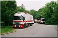
Lorries at Waddesdon
The layby on the edge of Waddesdon is a great place to overnight in a lorry. You're within easy walking distance of a picturesque village with a couple of good pubs, a village shop, a chippy and a curry house and there are - wonder of wonders! - toilet facilities provided in the layby. And no I don't mean having a wee up against the trailer wheels. Anyway, this was taken with an old film camera as I returned to my lorry from a photographic wander around Waddesdon.
Image: © John Winder
Taken: 7 Jun 2016
0.09 miles
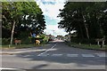
4
Baker Street, Waddesdon
Looking towards Switch dental practice
Image: © David Howard
Taken: 8 Jun 2019
0.12 miles
5
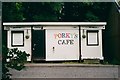
Porky's Cafe, Waddesdon
Note the correctly used apostrophe, which casued the sun to come out and the birds to sing in harmony when I spotted it. A small cafe, popular with lorry drivers and bikers, housed in a cabin in a layby near Waddesdon.
Image: © John Winder
Taken: 7 Jun 2016
0.13 miles
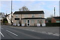
6
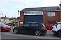
Vale Tyre Services on High Street, Waddesdon
Image: © David Howard
Taken: 16 Apr 2023
0.13 miles
7
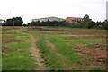
Cleared allotment patch
Cleared allotment patch just below Waddesdon School
Image: © Shaun Ferguson
Taken: 21 Sep 2007
0.15 miles
9
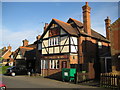
Waddesdon: The Bakers Arms
The old Ordnance Survey map of 1884 shows The Bakers Arms as a building set back some distance from the road. However by the time that the 1900 Edition was published it had been moved and rebuilt in its current location. The attractive terracotta tablet in the gable end has a carving of a baker at work using an oven. The road outside is of course called Baker Street.
Image: © Nigel Cox
Taken: 3 May 2009
0.15 miles