IMAGES TAKEN NEAR TO
The Close, AYLESBURY, HP18 0HX
Introduction
This page details the photographs taken nearby to The Close, HP18 0HX by members of the Geograph project.
The Geograph project started in 2005 with the aim of publishing, organising and preserving representative images for every square kilometre of Great Britain, Ireland and the Isle of Man.

There are currently over 7.5m images from over14,400 individuals and you can help contribute to the project by visiting https://www.geograph.org.uk
Image Map
Images are licensed for reuse under creativecommons.org/licenses/by-sa/2.0
Notes
- Clicking on the map will re-center to the selected point.
- The higher the marker number, the further away the image location is from the centre of the postcode.
Image Listing (36 Images Found)
Images are licensed for reuse under creativecommons.org/licenses/by-sa/2.0
Image
Details
Distance

2

Harvest time at Ashendon, Buckinghamshire
Image: © Roger Davies
Taken: 21 Aug 2010
0.04 miles
3
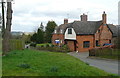
House on Main Street
Ashendon is not that large, 222 inhabitants apparently. You can be part of that number if you buy this house. I wonder if the nearest wall and roof have been rebuilt; the patterned brickwork strangely disappears under the eaves, unlike those sections adjacent. There also appears to be patterned tiling in the form of another X on the roof to the right. On the horizon to the left is the French-chateau-style Waddesdon Manor Image
Image: © Graham Horn
Taken: 10 Mar 2012
0.04 miles
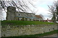
6
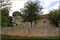
St Mary's, Ashendon
An OS cut mark is visible on the facing tower buttress. Image
Image: © Michael Trolove
Taken: 18 Nov 2012
0.05 miles
7
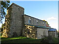
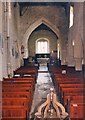
St Mary's Church, Ashendon
Ashendon is a small village of set along a ridge of land 9 miles west of Aylesbury and 7 miles north of Thame. St Mary's church stands on high ground on the southwest side of the village.
The earliest part of the church is the nave, built in the 12th century and having, at that time, a narrow south aisle that was lengthened, together with the nave in around 1200. About 90 years later the chancel and the old part of the south aisle was widened. Towards the close of the 15th century the west tower was built and a clerestory added to the nave, which had, at that time, a northeast chapel. The chancel was rebuilt in the 19th century. The chancel roof is a ‘wagon’ type, often seen in Devon and Cornwall.
Image: © Richard Rogerson
Taken: 8 Oct 2022
0.05 miles
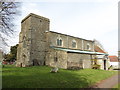
9
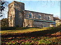
St Mary the Virgin, Ashendon
Early C12. The tower is C15.
Image: © Bikeboy
Taken: 1 Nov 2014
0.05 miles
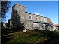
10
Ashendon church
Dedicated to St Mary. The earliest date is probably 12th century, but the nave was extended in the 13th century and heightened in the 15th century, with other 16th century alterations. There is a lot of architectural information here http://www.crsbi.ac.uk/search/county/site/ed-bk-ashen.html
Image: © Graham Horn
Taken: 10 Mar 2012
0.05 miles