IMAGES TAKEN NEAR TO
Dark Lane, AYLESBURY, HP18 0DA
Introduction
This page details the photographs taken nearby to Dark Lane, HP18 0DA by members of the Geograph project.
The Geograph project started in 2005 with the aim of publishing, organising and preserving representative images for every square kilometre of Great Britain, Ireland and the Isle of Man.

There are currently over 7.5m images from over14,400 individuals and you can help contribute to the project by visiting https://www.geograph.org.uk
Image Map
Images are licensed for reuse under creativecommons.org/licenses/by-sa/2.0
Notes
- Clicking on the map will re-center to the selected point.
- The higher the marker number, the further away the image location is from the centre of the postcode.
Image Listing (43 Images Found)
Images are licensed for reuse under creativecommons.org/licenses/by-sa/2.0
Image
Details
Distance
1
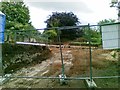
Development site, High Bank, Dark Lane, Chearsley
Image: © Alex McGregor
Taken: 21 Jun 2011
0.05 miles
2
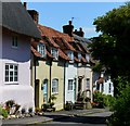
School Lane, Chearsley, Buckinghamshire
Image: © Oswald Bertram
Taken: 9 Jul 2015
0.07 miles
3
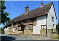
Old House, Chearsley, Buckinghamshire
C17 with C18 additions. Timber framed with brick infill on rubblestone plinth, 2 centre bays, then colourwashed and rendered east bay, and to west 2 bay rubblestone addition and 2 bay barn beyond, rubblestone lower part, colourwashed render upper part. Plain tile roofs. Timber frame bays have central door with gabled hood on brackets. Each bay has 3-light casements. C17 central stack of old thin bricks. East bay has 3-light ground floor casement. West bays have doorway at right, swept eaves breaking upper floor 3-light casement, two 2-light casements to ground floor with cambered brick arches. Left hand part has blocked barn door with casement over.
(Source:Historic England)
Image: © Oswald Bertram
Taken: 9 Jul 2015
0.09 miles
4
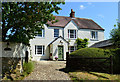
Village house, Chearsley, Buckinghamshire
Image: © Oswald Bertram
Taken: 9 Jul 2015
0.10 miles
5
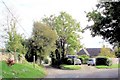
Chearsley, Stupp's Lane
Chearsley, view from Stupp's Lane ESE towards its junction with Watts Green (on left).
Image: © Mike Harris
Taken: 13 Oct 2007
0.10 miles
6
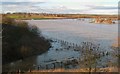
Chearsley from the Railway embankment during 2007 floods
Chearsley, Manor Farm, watermeadows and the Church, viewed across the River Thame Floods from the railway embankment in late afternoon sunlight on February 25 2007
Image: © Masquerade
Taken: 25 Feb 2007
0.11 miles
7
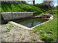
Pond and Water Pump, Chearsley (2)
This photo shows the pond and water pump in Church Lane HP18 0DF with a barrier of rocks to the left. It is unlikely that the water pump is still working and the pond has green algae in it.
Image: © David Hillas
Taken: 7 Apr 2022
0.12 miles
8

Pond and Water Pump, Chearsley (1)
Looking down Church Lane, this photo shows a pond and water pump. Just beyond the pond is a grey post with a small Public Footpath sign pointing to the left.
Image: © David Hillas
Taken: 7 Apr 2022
0.12 miles
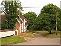
10
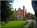
The Old Vicarage, Chearsley
Built around 1870. The architect was George Devey (1820-86) who is chiefly known for his work for the Rothschilds. See http://www.britishlistedbuildings.co.uk/en-42960-the-vicarage-chearsley-buckinghamshire for entry in British Listed Buildings
Image: © Bikeboy
Taken: 1 Nov 2014
0.13 miles