IMAGES TAKEN NEAR TO
Lower Icknield Way, AYLESBURY, HP17 9TX
Introduction
This page details the photographs taken nearby to Lower Icknield Way, HP17 9TX by members of the Geograph project.
The Geograph project started in 2005 with the aim of publishing, organising and preserving representative images for every square kilometre of Great Britain, Ireland and the Isle of Man.

There are currently over 7.5m images from over14,400 individuals and you can help contribute to the project by visiting https://www.geograph.org.uk
Image Map
Images are licensed for reuse under creativecommons.org/licenses/by-sa/2.0
Notes
- Clicking on the map will re-center to the selected point.
- The higher the marker number, the further away the image location is from the centre of the postcode.
Image Listing (2 Images Found)
Images are licensed for reuse under creativecommons.org/licenses/by-sa/2.0
Image
Details
Distance
1
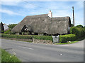
Clematis Cottage
Alongside the B4009, the cottage has more thatch than wall! I wonder how much light gets into the rooms. From the 1940's map the cottage appears to have been in a small village called Hatch Mead. Hatchmead farm further along the road bears testimony.
Image: © Martin Addison
Taken: 4 Jun 2006
0.08 miles
2
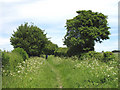
Bridleway across New Farm
With the spring growth of Cow Parsley, the bridleway has shrunk to a single track footpath. Tall hedges with trees border each side. The right hand hedge appears to have been carefully sculpted.
Image: © Martin Addison
Taken: 4 Jun 2006
0.23 miles