IMAGES TAKEN NEAR TO
Oxford Road, AYLESBURY, HP17 8TZ
Introduction
This page details the photographs taken nearby to Oxford Road, HP17 8TZ by members of the Geograph project.
The Geograph project started in 2005 with the aim of publishing, organising and preserving representative images for every square kilometre of Great Britain, Ireland and the Isle of Man.

There are currently over 7.5m images from over14,400 individuals and you can help contribute to the project by visiting https://www.geograph.org.uk
Image Map
Images are licensed for reuse under creativecommons.org/licenses/by-sa/2.0
Notes
- Clicking on the map will re-center to the selected point.
- The higher the marker number, the further away the image location is from the centre of the postcode.
Image Listing (8 Images Found)
Images are licensed for reuse under creativecommons.org/licenses/by-sa/2.0
Image
Details
Distance
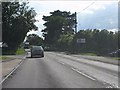
5
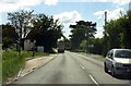
Bus stop on Oxford Road
The road on the left leads to Upton.
Image: © Steve Daniels
Taken: 25 May 2014
0.07 miles
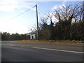
6
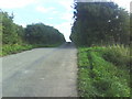
Lane from Starveall Farm
Looking up the lane from Starveall Farm towards the A418 Thame to Aylesbury road. The farm is famous for its Christmas turkeys.
Image: © Roger Templeman
Taken: 9 Sep 2010
0.13 miles
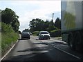
7
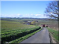
Valley near Stone
This is the valley of the River Thame. The river is not visible but it flows at the foot of the distant hills near Upper Winchendon. In the middle distance is Starveall Farm, with a white house in front of it. On the road, a tractor is taking rolls of hay towards the farm.
Image: © Andy Gryce
Taken: 18 Mar 2007
0.15 miles
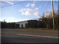
8
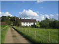
House near Starveall Farm, Stone
This unnamed house lies halfway between Starveall Farm about 1/2 km behind the camera, and the A418 road west of Stone. A footpath leaves the left hand side of the near the cottage, and the Aylesbury Ring footpath goes through the farm, but this section of road is not a public way. For the view in the opposite direction see Image
Image: © Andy Gryce
Taken: 19 May 2007
0.22 miles