IMAGES TAKEN NEAR TO
Kimblewick, AYLESBURY, HP17 8TD
Introduction
This page details the photographs taken nearby to HP17 8TD by members of the Geograph project.
The Geograph project started in 2005 with the aim of publishing, organising and preserving representative images for every square kilometre of Great Britain, Ireland and the Isle of Man.

There are currently over 7.5m images from over14,400 individuals and you can help contribute to the project by visiting https://www.geograph.org.uk
Image Map
Images are licensed for reuse under creativecommons.org/licenses/by-sa/2.0
Notes
- Clicking on the map will re-center to the selected point.
- The higher the marker number, the further away the image location is from the centre of the postcode.
Image Listing (4 Images Found)
Images are licensed for reuse under creativecommons.org/licenses/by-sa/2.0
Image
Details
Distance
1
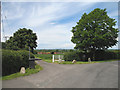
Kimblewick Farm
Gated entrance to Kimblewick Farm. The sign under the tree to the right reads 'Kimblewick C M Robarts Farm' and is made of welded horseshoes. A wheelie bin stands to the left of the entrance - even in the country you can't get away from them! The farm itself, visible through the gate, sits in grid square SP8107.
Image: © Martin Addison
Taken: 4 Jun 2006
0.02 miles
2

Blossom by the Aylesbury Ring
Where the path crosses Kimblewick Road.
Image: © Des Blenkinsopp
Taken: 17 Apr 2015
0.06 miles
3
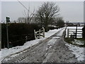
Footpath to Kimblewick
Footpath route of Aylesbury Ring/North Bucks Way to Kimblewick
Image: © Shaun Ferguson
Taken: 9 Feb 2009
0.10 miles
4
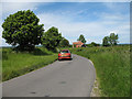
Kimblewick Road
View northwest along Kimblewick road. One of two isolated houses is shown.
Image: © Martin Addison
Taken: 4 Jun 2006
0.18 miles