IMAGES TAKEN NEAR TO
Kimblewick Road, AYLESBURY, HP17 8TB
Introduction
This page details the photographs taken nearby to Kimblewick Road, HP17 8TB by members of the Geograph project.
The Geograph project started in 2005 with the aim of publishing, organising and preserving representative images for every square kilometre of Great Britain, Ireland and the Isle of Man.

There are currently over 7.5m images from over14,400 individuals and you can help contribute to the project by visiting https://www.geograph.org.uk
Image Map (Loading...)


Getting Data...Please wait
Leaflet Map data © OpenStreetMap
Images are licensed for reuse under creativecommons.org/licenses/by-sa/2.0
Notes
- Clicking on the map will re-center to the selected point.
- The higher the marker number, the further away the image location is from the centre of the postcode.
Image Listing (3 Images Found)
Images are licensed for reuse under creativecommons.org/licenses/by-sa/2.0
Image
Details
Distance
1
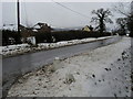
Kimblewick Road
Kimblewick Road by Roundhill Farm
Image: © Shaun Ferguson
Taken: 9 Feb 2009
0.02 miles
2
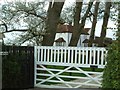
Roundhill Farm
One of several farms along Kimblewick Road. There are some disused-looking farm building on the opposite side of the road, so whether this is still the hub of a farm or not I don't know - certainly its sign omits the word "farm".
Image: © Rob Farrow
Taken: 29 Apr 2006
0.08 miles
3
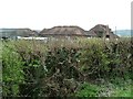
Unused farm buildings, Roundhill
These farm building seem to be unused at present but are still in good condition.
Image: © Rob Farrow
Taken: 29 Apr 2006
0.08 miles