IMAGES TAKEN NEAR TO
Marsh, AYLESBURY, HP17 8SR
Introduction
This page details the photographs taken nearby to HP17 8SR by members of the Geograph project.
The Geograph project started in 2005 with the aim of publishing, organising and preserving representative images for every square kilometre of Great Britain, Ireland and the Isle of Man.

There are currently over 7.5m images from over14,400 individuals and you can help contribute to the project by visiting https://www.geograph.org.uk
Image Map
Images are licensed for reuse under creativecommons.org/licenses/by-sa/2.0
Notes
- Clicking on the map will re-center to the selected point.
- The higher the marker number, the further away the image location is from the centre of the postcode.
Image Listing (6 Images Found)
Images are licensed for reuse under creativecommons.org/licenses/by-sa/2.0
Image
Details
Distance
4
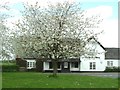
The Prince of Wales, Marsh
A flowering cherry (I think) partly obscures this pub in Marsh.
Image: © Rob Farrow
Taken: 29 Apr 2006
0.10 miles
5
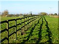
Pasture, Kimble
An area of paddocks beside a footpath to the west of Marsh Road.
Image: © Andrew Smith
Taken: 6 Dec 2014
0.19 miles
6
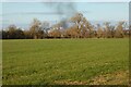
Pasture, Kimble
A field beside the farm-road and footpath to Apsley Manor Farm with bonfire smoke rising from somewhere in Marsh.
Image: © Andrew Smith
Taken: 27 Feb 2021
0.21 miles