IMAGES TAKEN NEAR TO
Rifle Range Lane, AYLESBURY, HP17 0XU
Introduction
This page details the photographs taken nearby to Rifle Range Lane, HP17 0XU by members of the Geograph project.
The Geograph project started in 2005 with the aim of publishing, organising and preserving representative images for every square kilometre of Great Britain, Ireland and the Isle of Man.

There are currently over 7.5m images from over14,400 individuals and you can help contribute to the project by visiting https://www.geograph.org.uk
Image Map
Images are licensed for reuse under creativecommons.org/licenses/by-sa/2.0
Notes
- Clicking on the map will re-center to the selected point.
- The higher the marker number, the further away the image location is from the centre of the postcode.
Image Listing (5 Images Found)
Images are licensed for reuse under creativecommons.org/licenses/by-sa/2.0
Image
Details
Distance
1
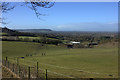
View towards Grange Farm from North Bucks Way
Image: © Robert Eva
Taken: 15 Feb 2018
0.12 miles
2
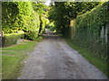
Upper Icknield Way
Upper Icknield Way bridleway to the Aylesbury Road
Image: © Shaun Ferguson
Taken: 3 Oct 2008
0.12 miles
3
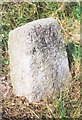
Old Milestone by the A4010, Aylesbury Road
Carved stone post by the A4010, in parish of Great and Little Kimble (Wycombe District), Aylesbury Road; by lane to Old Grange, North of Askett, on wide grass verge between road and hedge, on West side of road. Wycombe rough stone post, erected by the Ellesborough to West Wycombe turnpike trust in the 19th century.
Inscription reads:-
AYLESBURY
(6½)
WYCOMBE
(?)
PRINCES RISBORO
(2)
Carved benchmark and rivet on top of face.
Buckinghamshire HER.
HER Number: 1352700000 https://www.heritagegateway.org.uk/Gateway/Results_Single.aspx?uid=MBC25352&resourceID=1024
Milestone Society National ID: BU_WYAY10
Image: © A Rosevear & J Higgins
Taken: 3 Sep 2002
0.16 miles
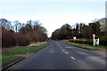
5
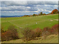
Scrub and paddocks, Kimble
A view of from the Ridgeway on Pulpit Hill of the hillside above Great Kimble.
Image: © Andrew Smith
Taken: 7 Nov 2010
0.24 miles