IMAGES TAKEN NEAR TO
Lodge Hill, AYLESBURY, HP17 0UR
Introduction
This page details the photographs taken nearby to Lodge Hill, HP17 0UR by members of the Geograph project.
The Geograph project started in 2005 with the aim of publishing, organising and preserving representative images for every square kilometre of Great Britain, Ireland and the Isle of Man.

There are currently over 7.5m images from over14,400 individuals and you can help contribute to the project by visiting https://www.geograph.org.uk
Image Map
Images are licensed for reuse under creativecommons.org/licenses/by-sa/2.0
Notes
- Clicking on the map will re-center to the selected point.
- The higher the marker number, the further away the image location is from the centre of the postcode.
Image Listing (32 Images Found)
Images are licensed for reuse under creativecommons.org/licenses/by-sa/2.0
Image
Details
Distance
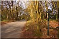
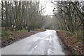
4
Road to Lodge Hill
Looking southwestwards from the Coombe Hill footpath
Image: © Robert Eva
Taken: 15 Feb 2018
0.09 miles
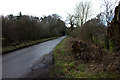
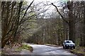
5
The road down Lodge Hill
The South Bucks Way cuts off left from the road down Lodge Hill
Image: © Shaun Ferguson
Taken: 23 Dec 2007
0.09 miles
7
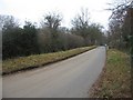
Country Lane
Looking away from Coombe Hill car park in the direction of Missenden Lane.
Image: © Mr Ignavy
Taken: 1 Jan 2009
0.11 miles
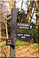
9
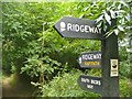
Lodge Hill
Following The Ridgeway and the South Bucks Way through beech woods east of Chequers.
Image: © Colin Smith
Taken: 14 Aug 2016
0.14 miles
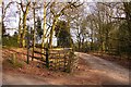
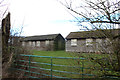
10
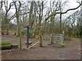
Gate at National Trust Coombe Hill boundary
The Ridgeway does a small dog-leg to the north here, as it enters NT land.
Image: © Robin Webster
Taken: 27 Mar 2015
0.16 miles