IMAGES TAKEN NEAR TO
Risborough Road, AYLESBURY, HP17 0UE
Introduction
This page details the photographs taken nearby to Risborough Road, HP17 0UE by members of the Geograph project.
The Geograph project started in 2005 with the aim of publishing, organising and preserving representative images for every square kilometre of Great Britain, Ireland and the Isle of Man.

There are currently over 7.5m images from over14,400 individuals and you can help contribute to the project by visiting https://www.geograph.org.uk
Image Map
Images are licensed for reuse under creativecommons.org/licenses/by-sa/2.0
Notes
- Clicking on the map will re-center to the selected point.
- The higher the marker number, the further away the image location is from the centre of the postcode.
Image Listing (2 Images Found)
Images are licensed for reuse under creativecommons.org/licenses/by-sa/2.0
Image
Details
Distance
1
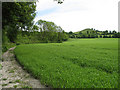
Footpath and Beacon Hill
Footpath following the line of The Springs, in the vicinity of Bushey Leys. An unidentified crop is growing well in the field. The colour of the path is indicative of the local chalkland. In the distance can be seen Beacon Hill.
Image: © Martin Addison
Taken: 4 Jun 2006
0.15 miles