IMAGES TAKEN NEAR TO
Lee Gate, GREAT MISSENDEN, HP16 9NW
Introduction
This page details the photographs taken nearby to HP16 9NW by members of the Geograph project.
The Geograph project started in 2005 with the aim of publishing, organising and preserving representative images for every square kilometre of Great Britain, Ireland and the Isle of Man.

There are currently over 7.5m images from over14,400 individuals and you can help contribute to the project by visiting https://www.geograph.org.uk
Image Map
Images are licensed for reuse under creativecommons.org/licenses/by-sa/2.0
Notes
- Clicking on the map will re-center to the selected point.
- The higher the marker number, the further away the image location is from the centre of the postcode.
Image Listing (6 Images Found)
Images are licensed for reuse under creativecommons.org/licenses/by-sa/2.0
Image
Details
Distance
1
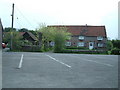
The Gate, Lee Gate
The Gate PH at Lee Gate (obvious name really). This pub often features live bands.
Image: © Rob Farrow
Taken: 10 May 2006
0.06 miles
2
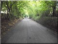
Chesham Lane near Lee Gate
A beech tree canopy covers this road
Image: © michael
Taken: 7 Oct 2012
0.06 miles
3
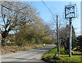
Name Sign at Lee Gate
The pub sign post for The Gate Inn has been given an artistic stencil cutout featuring the village name.
Image: © Des Blenkinsopp
Taken: 29 Mar 2019
0.06 miles
4
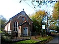
Former chapel, Lee Gate
Still marked as a chapel on the O.S. map but now a private dwelling. The plaque on the gable reads "Emmanuel Hall, 1883". See http://www.geograph.org.uk/photo/4230135 for a close up.
Image: © Bikeboy
Taken: 1 Nov 2014
0.19 miles
5
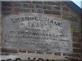
Plaque on gable of former chapel
See http://www.geograph.org.uk/photo/4230127 for a photo of the whole building.
Image: © Bikeboy
Taken: 1 Nov 2014
0.19 miles
6
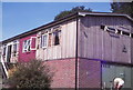
Lee Gate Youth Hostel, July 1979
Lee Gate Youth Hostel taken in July 1979. The hostel closed in 1983 and is now a private residence. Photo scanned from Agfacolor slide film.
Camera: Agfa Silette type 1
Film: Agfacolor
Image: © Jeff Buck
Taken: 14 Jul 1979
0.21 miles