IMAGES TAKEN NEAR TO
High Street, GREAT MISSENDEN, HP16 9EZ
Introduction
This page details the photographs taken nearby to High Street, HP16 9EZ by members of the Geograph project.
The Geograph project started in 2005 with the aim of publishing, organising and preserving representative images for every square kilometre of Great Britain, Ireland and the Isle of Man.

There are currently over 7.5m images from over14,400 individuals and you can help contribute to the project by visiting https://www.geograph.org.uk
Image Map
Images are licensed for reuse under creativecommons.org/licenses/by-sa/2.0
Notes
- Clicking on the map will re-center to the selected point.
- The higher the marker number, the further away the image location is from the centre of the postcode.
Image Listing (48 Images Found)
Images are licensed for reuse under creativecommons.org/licenses/by-sa/2.0
Image
Details
Distance
1
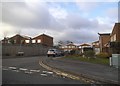
High Street, Prestwood looking East
This photo shows High Street looking east from the centre of the village. An Estate Agent can be seen to the left of the photo whilst the Methodist Church is in the distance to the left of High Street. Due to the current Covid-19 lockdown, there is hardly any traffic in this road.
Image: © David Hillas
Taken: 29 Apr 2020
0.03 miles
2
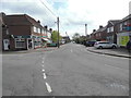
Chequers Lane, Prestwood
This photo shows Chequers Lane HP16 9DW from the centre of Prestwood village. The Chequers Tree pub can be seen to the left of the photo whilst an Estate Agent is across the road to the right.
Image: © David Hillas
Taken: 29 Apr 2020
0.03 miles
3
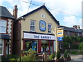
The Bakery, Prestwood
Located at 123 High Street, this bakery sells refreshments to take away. The wording on the sign says: Zoran's "Goodfillas", then under the baguette on the sign it says "Tea, Coffee & Cakes". The postcode of this shop is HP16 9EX. Update: The Bakery shop has since closed.
Image: © David Hillas
Taken: 24 Jul 2011
0.04 miles
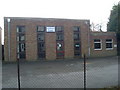
4
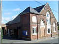
Prestwood Methodist Church (3)
Situated in High Street HP16 9EY, this photo shows the Church with the new white and glass entrance doors which were dedicated at the Church's 150th Anniversary Weekend in April 2013. This photo compares with the former photo showing the doors where the blue noticeboard is now positioned,http://www.geograph.org.uk/photo/1197686 refers.
Image: © David Hillas
Taken: 19 Jan 2014
0.04 miles
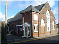
5
Prestwood Methodist Church (2)
Dating from 1972, the new hall is attached to the back of the Church. Photo is taken from Peters Close.
Image: © David Hillas
Taken: 9 Mar 2009
0.04 miles
6
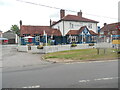
The Chequers Tree, Prestwood (2)
This photo shows The Chequers Tree public house which has recently been repainted outside. The previous photo of this public house is at https://www.geograph.org.uk/photo/4888641.
Image: © David Hillas
Taken: 30 Jun 2022
0.04 miles
7
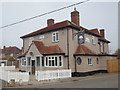
The Chequers Tree, Prestwood (1)
This refurbished pub is situated in the centre of Prestwood and serves food and drink daily. It recently replaced The Chequers Pub http://www.geograph.org.uk/photo/1370572 refers. For SatNav purposes, its postcode is HP16 9HD.
Image: © David Hillas
Taken: 12 Mar 2016
0.05 miles
8
Prestwood Methodist Church (1)
Situated in High Street, Prestwood, HP16 9EY, this Church dates from 1863. The front entrance was subsequently repositioned in early 2013 with the blue noticeboard being moved back, http://www.geograph.org.uk/photo/3824248 refers.
Image: © David Hillas
Taken: 29 Sep 2008
0.05 miles
9
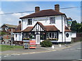
The Chequers Inn, Prestwood
Situated at the corner of the High Street, Chequers Lane and Honor End Lane in Prestwood. Its postcode is HP16 9HD. Recently, this pub has been refurbished and is now called "The Chequers Tree" http://www.geograph.org.uk/photo/4888641 refers.
Image: © David Hillas
Taken: 22 Jun 2009
0.05 miles