IMAGES TAKEN NEAR TO
Weathercock Gardens, HIGH WYCOMBE, HP15 6TA
Introduction
This page details the photographs taken nearby to Weathercock Gardens, HP15 6TA by members of the Geograph project.
The Geograph project started in 2005 with the aim of publishing, organising and preserving representative images for every square kilometre of Great Britain, Ireland and the Isle of Man.

There are currently over 7.5m images from over14,400 individuals and you can help contribute to the project by visiting https://www.geograph.org.uk
Image Map (34 Images)


Getting Data...Please wait
Leaflet Map data © OpenStreetMap
Images are licensed for reuse under creativecommons.org/licenses/by-sa/2.0
Notes
- Clicking on the map will re-center to the selected point.
- The higher the marker number, the further away the image location is from the centre of the postcode.
Image Listing (34 Images Found)
Images are licensed for reuse under creativecommons.org/licenses/by-sa/2.0
Image
Details
Distance
1
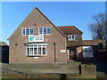
Former Telephone Exchange, Holmer Green
Situated in New Pond Road, Holmer Green, HP15 6SU, this former TE is now a wholesale book store. It was replaced in the early 1970s by the TE off Primrose Hill, Widmer End, SU8897 refers http://www.geograph.org.uk/photo/1074621. Update: this former TE has recently been converted into five apartments, the name being "The Old Exchange" http://www.geograph.org.uk/photo/5968872 refers.
Image: © David Hillas
Taken: 6 Dec 2008
0.05 miles
2
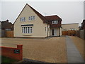
The Old Exchange, Holmer Green
Situated in New Pond Road HP15 6SU, this building used to be a wholesale book store, but has been refurbished and now comprises of five apartments http://www.geograph.org.uk/photo/1074615 refers. Previously, it was Holmer Green Telephone Exchange until it was replaced by the current TE in Primrose Hill, Widmer End in the early 1970s http://www.geograph.org.uk/photo/1074621 refers. The television aerial on its roof is directed towards the TV transmitter at Crystal Palace in South London, TQ3371 refers. The name "The Old Exchange" can be seen on the brick wall to the left of the photo.
Image: © David Hillas
Taken: 6 Nov 2018
0.06 miles
3
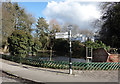
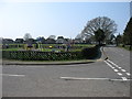
Pond on the Corner, Holmer Green
Village pond by the crossroads.
Image: © Des Blenkinsopp
Taken: 7 Mar 2018
0.07 miles
4
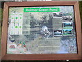
Information Board at Holmer Green Pond
This information board which has been erected by the Holmer Green Village Society, is located at the junction of Earl Howe Road and Pond Approach. It has the following wording:
Holmer Green Pond
Left side
Illustrations of:
Hornbeam Yew Oak
Larch Horse Chestnut Willow
Archangel Bluebell Flag
FLORA & FAUNA
Between 1960 and 1980 the pond underwent several renovations which changed the
topography and the flora and fauna. Reeds were removed, trees planted and wild
fowl introduced.
There are now many indigenous trees from Oak and Larch, adjacent to Pond
Approach, to Hornbeam, Willow and Yew on the other side. In addition there are
Horse Chestnut, Lawson's Cypress, Norway Spruce, Ash, Beech and Sycamore trees.
Ground cover is mainly Ivy and Brambles, but there are also Yellow Archangel
and Bluebells. In 2018 new water plants were introduced including Yellow Flag,
Juncus and Carex.
Moorhen, Mallard and a crossbreed of Mallard and Indian Rubber Duck are
frequently seen on Holmer Green pond.
In the lower left are illustrations of Moorhen, Mallard, Mallard/Rubber Duck
whilst in the middle is an illustration of the pond itself.
Right side
HISTORY
'Holmer' was first recorded as 'Holeme' in 1208 and is probably Anglo Saxon in
origin. Commonly thought to derive from 'mere hollow' which would refer to
Holmer Pond, however the first official mention of the pond was in the 1578
Boundary Survey. Holmer Green is a mile from the river Misbourne and therefore
this, and other local ponds, were a very important source of water for both
farm animals and domestic use. Ducks were banned as they polluted the water.
Photos of Holmer Green Pond taken in 1905, 1966, 1966, 1998, 2009 in a
clockwise direction.
HOLMER GREEN
Holmer Green is named after the manor of Holmer that covered a significant part
of the parish of Little Missenden in the Middle Ages.
The early history of the village is essentially one of people moving out of
Little Missenden over the centuries and settling on a large area of heath (now
vanished) known as Wycombe Heath or Holmer Heath. The 'Green' part of the name
refers to a large and ancient Green, probably dating from the 13th century that
used to exist here but was reduced to a size of only 4 acres (1.6 ha) in 1854.
In the hundred years between 1850 and 1950, the village became well-known
locally for its cherry orchards, and there remain many references to orchards
and cherries in road names and house names. In 2008 the village formerly
celebrated 800 years of recorded settlement.
Image: © David Hillas
Taken: 17 Mar 2020
0.08 miles
5
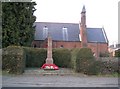
Holmer Green: The War Memorial
This simple stone, on the north side of Beech Tree Road in front of Christ Church, commemorates 14 Holmer Green men who gave their lives during conflicts.
Image: © Nigel Cox
Taken: 10 Feb 2008
0.08 miles
7
Navigating northwards up the Bashire (63)
Lynford Parade: October 2024
Image: © Basher Eyre
Taken: 29 Oct 2024
0.11 miles
8
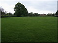
Village Green, Holmer Green
Used as a recreation ground.
Image: © David Purchase
Taken: 9 Apr 2015
0.12 miles
9
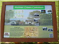
Information Board at Holmer Green Common
This information board, which has been erected by the Holmer Green Village Society, is at the east end of the Common HP15 6TD, and shows a view looking towards the north end of The Common with Holmer Green Village Hall to the left of the board. It has the following wording:
Top left
FLORA
The most notable tree is the magnificent Horse Chestnut which stands in the
North West corner. Many species of tree are planted around the perimeter
amongst them are Beech, Silver Birch, Japanese Crab Apple, Mountain Ash,
Swedish Whitebeam, Lime, Cherry, Holly, Sycamore, Field Maple and probably the
oldest tree here, the English Oak. Scan the QR code below for information about
all the trees around the Common.
Images of English Oak, Field Maple, Horse Chestnut, Cherry, Silver Birch and
Whitebeam.
Lower left
HOLMER GREEN
The first real glimpse of our village as a whole is through the 1742 map of the
Manor of Holmer where we see a very open landscape with ancient woodland on the
outskirts. We also see an established but scattered settled population. Most
of these inhabitants would be involved in farming and general rural pursuits.
We see the first evidence of fruit growing and in some of the place names much
evidence of sheep rearing and droving. We can also identify some of the
buildings that survive to this day. This 1742 layout of the village remained
almost unaltered until Holmer Green was enclosed by act of parliament in 1854
when the road lay-out we know today was introduced.
Map: Holmer green; 1854 Common inserted on the 1742 Manor map.
Top right
THE COMMON
It could be said that our hill top village has two main centres with the first
being around the cross roads with our ancient pond and shops. The attractive
and busy area of the Common provides the second focal point. Around its three
sides you will find the Middle School and Baptist Church, while the Bat and
Ball pub stands proud on one corner overlooking the children's playground.
The Church community hall lies adjacent to Christ Church. which modestly
dominates the skyline with its high perched golden cockerel weather vane. The
main village hall known as the Village Centre evolved from the Victorian
school. Further around the Common is the original Baptist Chapel which is now
converted to a dwelling. On the south side is the Clementi estate that up until
the 1970s was the country house known as Holmer Court, home to Sir Cecil and
Lady Clementi.
Photos (top right anticlockwise to lower right)
i) Peddles Cottage c.1910
ii) The Common 2008
iii) The Bat & Ball c.1950
iv) Christ Church c.1905
v) Sunnyside & The Old School 1900
vi) The White House 1899
vii) Baptist Chapel Late 1920s
Image: © David Hillas
Taken: 19 Sep 2020
0.13 miles
10

The Village Centre, Holmer Green
Situated on the north side of The Common, HP15 6XG, this village hall is hired out to various organisations in the area. To the left of the centre below "The Village Centre" board, can be seen a poster for the Holmer Green Village Centre Pre-School. On the extreme right of the photo is the village centre noticeboard whilst the car park is in the foreground.
Image: © David Hillas
Taken: 25 Jan 2019
0.13 miles