Information Board at Holmer Green Common
Introduction
The photograph on this page of Information Board at Holmer Green Common by David Hillas as part of the Geograph project.
The Geograph project started in 2005 with the aim of publishing, organising and preserving representative images for every square kilometre of Great Britain, Ireland and the Isle of Man.

There are currently over 7.5m images from over 14,400 individuals and you can help contribute to the project by visiting https://www.geograph.org.uk
Information Board at Holmer Green Common
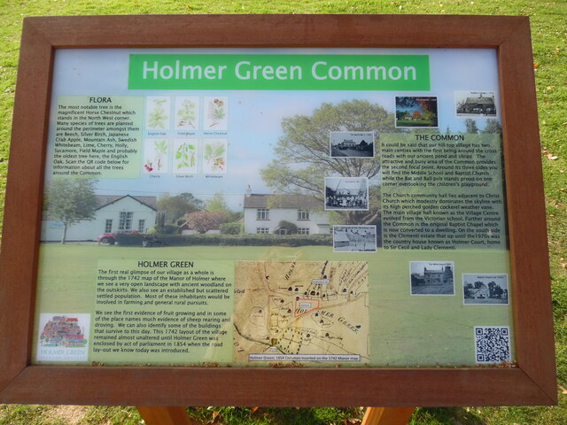
Image: © David Hillas Taken: 19 Sep 2020
This information board, which has been erected by the Holmer Green Village Society, is at the east end of the Common HP15 6TD, and shows a view looking towards the north end of The Common with Holmer Green Village Hall to the left of the board. It has the following wording: Top left FLORA The most notable tree is the magnificent Horse Chestnut which stands in the North West corner. Many species of tree are planted around the perimeter amongst them are Beech, Silver Birch, Japanese Crab Apple, Mountain Ash, Swedish Whitebeam, Lime, Cherry, Holly, Sycamore, Field Maple and probably the oldest tree here, the English Oak. Scan the QR code below for information about all the trees around the Common. Images of English Oak, Field Maple, Horse Chestnut, Cherry, Silver Birch and Whitebeam. Lower left HOLMER GREEN The first real glimpse of our village as a whole is through the 1742 map of the Manor of Holmer where we see a very open landscape with ancient woodland on the outskirts. We also see an established but scattered settled population. Most of these inhabitants would be involved in farming and general rural pursuits. We see the first evidence of fruit growing and in some of the place names much evidence of sheep rearing and droving. We can also identify some of the buildings that survive to this day. This 1742 layout of the village remained almost unaltered until Holmer Green was enclosed by act of parliament in 1854 when the road lay-out we know today was introduced. Map: Holmer green; 1854 Common inserted on the 1742 Manor map. Top right THE COMMON It could be said that our hill top village has two main centres with the first being around the cross roads with our ancient pond and shops. The attractive and busy area of the Common provides the second focal point. Around its three sides you will find the Middle School and Baptist Church, while the Bat and Ball pub stands proud on one corner overlooking the children's playground. The Church community hall lies adjacent to Christ Church. which modestly dominates the skyline with its high perched golden cockerel weather vane. The main village hall known as the Village Centre evolved from the Victorian school. Further around the Common is the original Baptist Chapel which is now converted to a dwelling. On the south side is the Clementi estate that up until the 1970s was the country house known as Holmer Court, home to Sir Cecil and Lady Clementi. Photos (top right anticlockwise to lower right) i) Peddles Cottage c.1910 ii) The Common 2008 iii) The Bat & Ball c.1950 iv) Christ Church c.1905 v) Sunnyside & The Old School 1900 vi) The White House 1899 vii) Baptist Chapel Late 1920s
Images are licensed for reuse under creativecommons.org/licenses/by-sa/2.0
Image Location


Leaflet Map data © OpenStreetMap
Latitude
51.667179
Longitude
-0.691087