IMAGES TAKEN NEAR TO
Cryers Hill Road, HIGH WYCOMBE, HP15 6JS
Introduction
This page details the photographs taken nearby to Cryers Hill Road, HP15 6JS by members of the Geograph project.
The Geograph project started in 2005 with the aim of publishing, organising and preserving representative images for every square kilometre of Great Britain, Ireland and the Isle of Man.

There are currently over 7.5m images from over14,400 individuals and you can help contribute to the project by visiting https://www.geograph.org.uk
Image Map
Images are licensed for reuse under creativecommons.org/licenses/by-sa/2.0
Notes
- Clicking on the map will re-center to the selected point.
- The higher the marker number, the further away the image location is from the centre of the postcode.
Image Listing (6 Images Found)
Images are licensed for reuse under creativecommons.org/licenses/by-sa/2.0
Image
Details
Distance
2
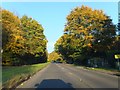
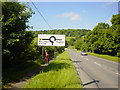
Autumn colour by the A4128
The A4128 climbs out of Hughenden Valley to Cryers Hill
Image: © David Smith
Taken: 26 Oct 2011
0.10 miles
3
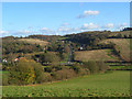
Countryside, Hughenden Valley
Looking down from pasture below Woodcock Wood. The A4128 can be seen climbing to Cryer's Hill.
Image: © Andrew Smith
Taken: 22 Nov 2008
0.19 miles
4
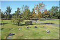
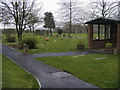
Seat in the Cemetery
A very well looked after cemetery along Four Ashes Road.
Image: © Des Blenkinsopp
Taken: 18 Sep 2019
0.22 miles
6
Cemetery on Four Ashes Road
Cemetery on Four Ashes Road near Cryers Hill
Image: © Shaun Ferguson
Taken: 22 Mar 2008
0.25 miles