IMAGES TAKEN NEAR TO
Hoppers Way, HIGH WYCOMBE, HP15 6EY
Introduction
This page details the photographs taken nearby to Hoppers Way, HP15 6EY by members of the Geograph project.
The Geograph project started in 2005 with the aim of publishing, organising and preserving representative images for every square kilometre of Great Britain, Ireland and the Isle of Man.

There are currently over 7.5m images from over14,400 individuals and you can help contribute to the project by visiting https://www.geograph.org.uk
Image Map
Images are licensed for reuse under creativecommons.org/licenses/by-sa/2.0
Notes
- Clicking on the map will re-center to the selected point.
- The higher the marker number, the further away the image location is from the centre of the postcode.
Image Listing (30 Images Found)
Images are licensed for reuse under creativecommons.org/licenses/by-sa/2.0
Image
Details
Distance
1
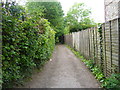
Enclosed Path from Cockpit Road
This enclosed public footpath leads from Cockpit Road, then across Hughenden Parish Field at Great Kingshill to Common Road.
Image: © Sean Davis
Taken: 22 May 2009
0.05 miles
2
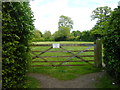
Parish Field Great Kingshill
Hughenden Parish Council taken from Common Road. As you can partly see there is a wide gap either side of the gate. I assume no animals are kept here and the gate is to stop vehicles. A public footpath leads directly across the centre of field and becomes enclosed before leading to Cockpit Road.
Image: © Sean Davis
Taken: 22 May 2009
0.05 miles
3
Pond and cottage, Great Kingshill
The quantity of water in the pond is symptomatic of the lack of rainfall in south-east England.
Image: © Andrew Smith
Taken: 2 Apr 2006
0.10 miles
4

Royal Oak Mews
New housing built using brick and flint, the traditional materials in this area.
Image: © Des Blenkinsopp
Taken: 7 Mar 2018
0.14 miles
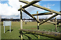
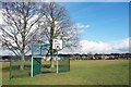
5
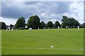
Cricket at Great Kingshill
Cricket match on The Common at Great Kingshill. This is on the route of the London Green Belt Way.
Image: © Sean Davis
Taken: 28 Jul 2007
0.14 miles
7
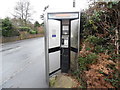
Former KX300 Telephone Kiosk, Great Kingshill
Situated in Stag Lane HP15 6EW, this telephone kiosk has a BT notice on its left indicating that this kiosk will shortly be removed due to lack of usage. Update: this telephone kiosk has since been taken out.
Image: © David Hillas
Taken: 23 Dec 2016
0.15 miles
8
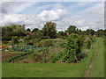
Allotments, Great Kingshill
By the common, view from public car park.
Image: © David Hawgood
Taken: 30 Aug 2006
0.15 miles
9
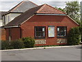
Hughenden Parish Council office
This small office by the common in Great Kingshill is for Hughenden Parish Council, which covers six villages just north of High Wycombe.
Image: © David Hawgood
Taken: 30 Aug 2006
0.15 miles
10
Basketball on The Common
Great Kingshill Common, a recreation ground in the centre of the village.
Image: © Des Blenkinsopp
Taken: 7 Mar 2018
0.16 miles