IMAGES TAKEN NEAR TO
Windmill Lane, HIGH WYCOMBE, HP15 6AL
Introduction
This page details the photographs taken nearby to Windmill Lane, HP15 6AL by members of the Geograph project.
The Geograph project started in 2005 with the aim of publishing, organising and preserving representative images for every square kilometre of Great Britain, Ireland and the Isle of Man.

There are currently over 7.5m images from over14,400 individuals and you can help contribute to the project by visiting https://www.geograph.org.uk
Image Map (Loading...)


Getting Data...Please wait
Leaflet Map data © OpenStreetMap
Images are licensed for reuse under creativecommons.org/licenses/by-sa/2.0
Notes
- Clicking on the map will re-center to the selected point.
- The higher the marker number, the further away the image location is from the centre of the postcode.
Image Listing (3 Images Found)
Images are licensed for reuse under creativecommons.org/licenses/by-sa/2.0
Image
Details
Distance
2
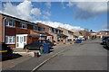
Snowdrop Way, Widmer End
Off Primrose Hill. Honeysuckle, Cowslip, Marigold, Larkspur and Campion are all nearby street names. Obviously a gardener in the street naming office when these were built.
Image: © Des Blenkinsopp
Taken: 7 Mar 2018
0.21 miles
3
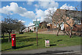
No Dirty Dogs
Primrose Green, an open space for residents along George's Hill. Dogs appear to be a problem.
Image: © Des Blenkinsopp
Taken: 7 Mar 2018
0.22 miles