IMAGES TAKEN NEAR TO
Kilnwood, HIGH WYCOMBE, HP14 4UN
Introduction
This page details the photographs taken nearby to Kilnwood, HP14 4UN by members of the Geograph project.
The Geograph project started in 2005 with the aim of publishing, organising and preserving representative images for every square kilometre of Great Britain, Ireland and the Isle of Man.

There are currently over 7.5m images from over14,400 individuals and you can help contribute to the project by visiting https://www.geograph.org.uk
Image Map (Loading...)


Getting Data...Please wait
Leaflet Map data © OpenStreetMap
Images are licensed for reuse under creativecommons.org/licenses/by-sa/2.0
Notes
- Clicking on the map will re-center to the selected point.
- The higher the marker number, the further away the image location is from the centre of the postcode.
Image Listing (4 Images Found)
Images are licensed for reuse under creativecommons.org/licenses/by-sa/2.0
Image
Details
Distance
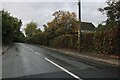
1
Main road Walter's Ash
Main road Walter's Ash junction with Bradenham Wood lane
Image: © Shaun Ferguson
Taken: 20 Sep 2008
0.17 miles
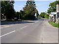
2
Main Road junction with Bradenham Wood Lane
Image: © Stuart Logan
Taken: 30 Jul 2014
0.18 miles
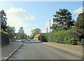
3
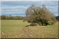
Farmland, Hughenden
A footpath crossing arable farmland before a steep descent into the valley to the right. A short stretch of hedgerow and trees stands isolated in the field.
Image: © Andrew Smith
Taken: 2 Jan 2022
0.22 miles