IMAGES TAKEN NEAR TO
Main Road, HIGH WYCOMBE, HP14 4SB
Introduction
This page details the photographs taken nearby to Main Road, HP14 4SB by members of the Geograph project.
The Geograph project started in 2005 with the aim of publishing, organising and preserving representative images for every square kilometre of Great Britain, Ireland and the Isle of Man.

There are currently over 7.5m images from over14,400 individuals and you can help contribute to the project by visiting https://www.geograph.org.uk
Image Map
Images are licensed for reuse under creativecommons.org/licenses/by-sa/2.0
Notes
- Clicking on the map will re-center to the selected point.
- The higher the marker number, the further away the image location is from the centre of the postcode.
Image Listing (8 Images Found)
Images are licensed for reuse under creativecommons.org/licenses/by-sa/2.0
Image
Details
Distance
1
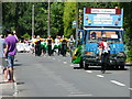
The Naphill carnival passes Great Moseley Farm
Image: © Peter Jemmett
Taken: 10 Jun 2006
0.04 miles
2
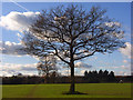
Farmland, Naphill
A small oak with the footpath to Great Moseley Farm to its left.
Image: © Andrew Smith
Taken: 22 Nov 2008
0.15 miles
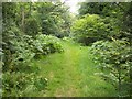
4
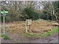
Footpaths on Naphill Common
Footpaths on Naphill Common by Chapel Lane
Image: © Shaun Ferguson
Taken: 22 Mar 2008
0.19 miles
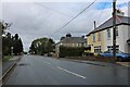
5
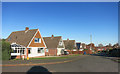
Battingswood Gardens, Walter's Ash
Battings Wood is at the other end of the street.
Image: © Des Blenkinsopp
Taken: 28 Nov 2016
0.23 miles
8
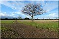
Farmland, Hughenden
The footpath heading towards Great Moseley Farm crossing an arable field.
Image: © Andrew Smith
Taken: 2 Jan 2022
0.25 miles