IMAGES TAKEN NEAR TO
Coombe Lane, HIGH WYCOMBE, HP14 4QR
Introduction
This page details the photographs taken nearby to Coombe Lane, HP14 4QR by members of the Geograph project.
The Geograph project started in 2005 with the aim of publishing, organising and preserving representative images for every square kilometre of Great Britain, Ireland and the Isle of Man.

There are currently over 7.5m images from over14,400 individuals and you can help contribute to the project by visiting https://www.geograph.org.uk
Image Map (Loading...)


Getting Data...Please wait
Leaflet Map data © OpenStreetMap
Images are licensed for reuse under creativecommons.org/licenses/by-sa/2.0
Notes
- Clicking on the map will re-center to the selected point.
- The higher the marker number, the further away the image location is from the centre of the postcode.
Image Listing (21 Images Found)
Images are licensed for reuse under creativecommons.org/licenses/by-sa/2.0
Image
Details
Distance
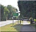
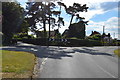
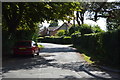
3
Hunts Hill Lane at the junction of Coombe Lane
Image: © David Howard
Taken: 27 Sep 2022
0.08 miles
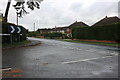
6
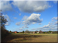
Farmland, Naphill
Looking towards houses on Coombe Lane.
Image: © Andrew Smith
Taken: 22 Nov 2008
0.10 miles
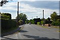
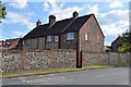
10
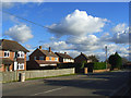
Main Road, Naphill
Looking towards the bend in the road where it becomes Coombe Lane. The majority of the village is post-war housing with scattered older properties.
Image: © Andrew Smith
Taken: 22 Nov 2008
0.12 miles