IMAGES TAKEN NEAR TO
Louches Lane, HIGH WYCOMBE, HP14 4QH
Introduction
This page details the photographs taken nearby to Louches Lane, HP14 4QH by members of the Geograph project.
The Geograph project started in 2005 with the aim of publishing, organising and preserving representative images for every square kilometre of Great Britain, Ireland and the Isle of Man.

There are currently over 7.5m images from over14,400 individuals and you can help contribute to the project by visiting https://www.geograph.org.uk
Image Map (Loading...)


Getting Data...Please wait
Leaflet Map data © OpenStreetMap
Images are licensed for reuse under creativecommons.org/licenses/by-sa/2.0
Notes
- Clicking on the map will re-center to the selected point.
- The higher the marker number, the further away the image location is from the centre of the postcode.
Image Listing (30 Images Found)
Images are licensed for reuse under creativecommons.org/licenses/by-sa/2.0
Image
Details
Distance
1

Oakeshott Avenue, Naphill
A short residential cul de sac off Louches Lane.
Image: © Des Blenkinsopp
Taken: 28 Nov 2016
0.04 miles
2

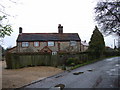
Allotments, Naphill
From the Louches Lane end. The houses are on Main Road.
Image: © Des Blenkinsopp
Taken: 28 Nov 2016
0.08 miles

4

Main Road, Naphill
The junction with Louches Lane.
Image: © Andrew Smith
Taken: 22 Nov 2008
0.12 miles
5
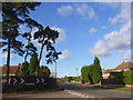
Main Road, Naphill
Pines standing at the junction with Hunt's Hill Lane.
Image: © Andrew Smith
Taken: 22 Nov 2008
0.13 miles
6

Naphill Playing Fields
Football goals on Naphill Playing Fields
Image: © Shaun Ferguson
Taken: 22 Mar 2008
0.16 miles

9

Naphill Telephone Exchange, Bucks
This TE is located at 88 Main Road, Naphill, HP14 4QA and has the code SMNPL. It provides telephone and broadband services to 2,481 residential and 97 non-residential premises in Naphill, plus Bradenham, Hughenden Valley, North Dean and Walter's Ash nearby. The numbering range for this TE is (01494) 56xxxx, the (01494) referring to the High Wycombe group of sixteen TEs.
Image: © David Hillas
Taken: 28 Feb 2009
0.18 miles