IMAGES TAKEN NEAR TO
Bramley End, HIGH WYCOMBE, HP14 4NS
Introduction
This page details the photographs taken nearby to Bramley End, HP14 4NS by members of the Geograph project.
The Geograph project started in 2005 with the aim of publishing, organising and preserving representative images for every square kilometre of Great Britain, Ireland and the Isle of Man.

There are currently over 7.5m images from over14,400 individuals and you can help contribute to the project by visiting https://www.geograph.org.uk
Image Map (Loading...)


Getting Data...Please wait
Leaflet Map data © OpenStreetMap
Images are licensed for reuse under creativecommons.org/licenses/by-sa/2.0
Notes
- Clicking on the map will re-center to the selected point.
- The higher the marker number, the further away the image location is from the centre of the postcode.
Image Listing (20 Images Found)
Images are licensed for reuse under creativecommons.org/licenses/by-sa/2.0
Image
Details
Distance
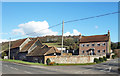
1
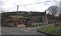
Lower Warren Farm, Hughenden Valley
Photograph looking northeast from junction of Warrendene Road, Bryant Bottom Road, Hampden Road and Hatches Lane.
Image: © David Ellis
Taken: 17 Feb 2006
0.06 miles
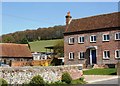
2
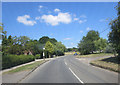
Warrendene Road junction with Bramley End
Bramley End is a tiny cul-de-sac on the left; opposite the diminutive crescent of Dene Road.
Image: © Stuart Logan
Taken: 30 Jul 2014
0.08 miles
4
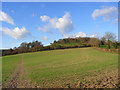
Sherwood Farm
Almost an alpine meadow scene, just needs a mighty Alp in the background.
Image: © Michael Trolove
Taken: 26 May 2013
0.11 miles
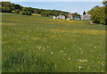
6
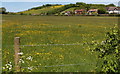
Pasture land
Grazing land near Upper North Dean. An abundance of Buttercups in 2013.
Image: © Michael Trolove
Taken: 26 May 2013
0.13 miles
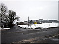
8
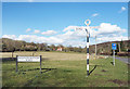
Signpost, Bryants Bottom Road
A rural chiltern crossroads.
Image: © Des Blenkinsopp
Taken: 7 Mar 2018
0.16 miles
9
A view below Piggot's Wood towards Pipers Corner
The footpath is clearly seen.
Image: © Michael Trolove
Taken: 26 May 2013
0.16 miles
10
Farmland, Hughenden
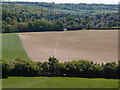
With a footpath crossing the cereal field and Piggott's Wood on the hilltop beyond pasture.
Image: © Andrew Smith
Taken: 22 Nov 2008
0.19 miles